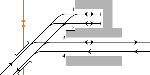
File:Rail Tracks map Kintetsu Ujiyamada Station.svg

Original file (SVG file, nominally 480 × 240 pixels, file size: 10 KB)
Captions
Captions
Summary[edit]
| DescriptionRail Tracks map Kintetsu Ujiyamada Station.svg |
English: Rail tracks map of Kintetsu Kintetsu Nagoya Station in Ise, Mie Pref., Japan.
Reference material: Ryozo KAWASHIMA, "Zenkoku Tetsudo Jijyo Daikenkyu - Nagoya Toshimbu and Mie", ISBN 978-4-7942-0700-5, 211p., Soshisha, 1996. 日本語: 三重県伊勢市にある近畿日本鉄道 宇治山田駅構内配線略図
参考文献:川島令三、『全国鉄道事情大研究 - 名古屋都心部・三重篇』、ISBN 978-4-7942-0700-5、211p、草思社、1996 凡例は駅配線図テンプレートを参照Français : Plan de voies |
|||
| Date | ||||
| Source | Tawashi2006 created from icons in Category:Rail_tracks_map_template. | |||
| Author | Tawashi2006 with pdv2svg | |||
| Permission (Reusing this file) |
|
File history
Click on a date/time to view the file as it appeared at that time.
| Date/Time | Thumbnail | Dimensions | User | Comment | |
|---|---|---|---|---|---|
| current | 13:58, 23 July 2009 |  | 480 × 240 (10 KB) | Tawashi2006 (talk | contribs) | == Summary == {{Information |Description = {{en|1=Rail tracks map of Kintetsu '''Kintetsu Nagoya Station''' in Ise, Mie Pref., Japan. <br />Reference material: Ryozo |
You cannot overwrite this file.
File usage on Commons
There are no pages that use this file.
File usage on other wikis
The following other wikis use this file:
- Usage on en.wikipedia.org
- Usage on eo.wikipedia.org
- Usage on ja.wikipedia.org
- Usage on zh.wikipedia.org
Metadata
This file contains additional information such as Exif metadata which may have been added by the digital camera, scanner, or software program used to create or digitize it. If the file has been modified from its original state, some details such as the timestamp may not fully reflect those of the original file. The timestamp is only as accurate as the clock in the camera, and it may be completely wrong.
| Short title | Rail_Tracks_map_Kintetsu_Ujiyamada_Station |
|---|