File:Ratanakiri districts.jpg
Jump to navigation
Jump to search
No higher resolution available.
Ratanakiri_districts.jpg (392 × 541 pixels, file size: 43 KB, MIME type: image/jpeg)
Captions
Captions
Add a one-line explanation of what this file represents
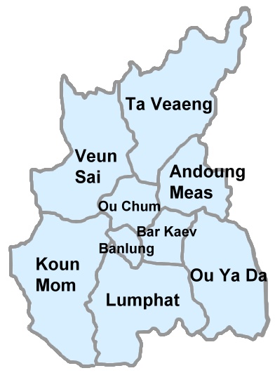
| Description | Map of Ratanakiri Province with districts outlined |
| Date | |
| Source | self-made based on http://www.tourismcambodia.com/TravelGuides/images/Rattanakiri_Map.jpg |
| Author | Mangostar |
| Permission (Reusing this file) |
This file is licensed under the Creative Commons Attribution-Share Alike 3.0 Unported license.
|
File history
Click on a date/time to view the file as it appeared at that time.
| Date/Time | Thumbnail | Dimensions | User | Comment | |
|---|---|---|---|---|---|
| current | 15:14, 29 April 2008 | | 392 × 541 (43 KB) | Calliopejen1 (talk | contribs) | {{Information |Description=Map of Ratanakiri Province with districts outlined |Source=self-made based on http://www.tourismcambodia.com/TravelGuides/images/Rattanakiri_Map.jpg |Date=2008-04-29 |Author=Mangostar |Permission={{cc-by-sa-3.0}} |other_versions |
You cannot overwrite this file.
File usage on Commons
There are no pages that use this file.
File usage on other wikis
The following other wikis use this file:
- Usage on bg.wikipedia.org
- Usage on de.wikipedia.org
- Usage on en.wikipedia.org
- Usage on es.wikipedia.org
- Usage on fa.wikipedia.org
- Usage on fr.wikipedia.org
- Usage on id.wikipedia.org
- Usage on ilo.wikipedia.org
- Usage on it.wikipedia.org
- Usage on km.wikipedia.org
- Usage on no.wikipedia.org
- Usage on pt.wikipedia.org
- Usage on ru.wikipedia.org
- Usage on vi.wikipedia.org
- Usage on www.wikidata.org
- Usage on zh.wikipedia.org