File:Regiones precolombinas en Guatemala.png
Jump to navigation
Jump to search
Size of this preview: 654 × 600 pixels. Other resolutions: 262 × 240 pixels | 524 × 480 pixels | 720 × 660 pixels.
Original file (720 × 660 pixels, file size: 290 KB, MIME type: image/png)
Captions
Captions
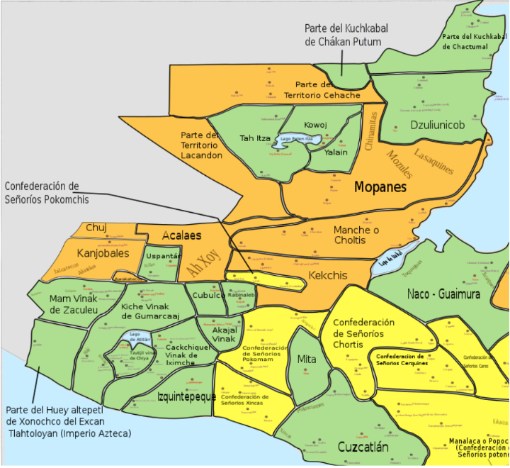
Map of the pre-Columbian regions of Guatemala
Summary[edit]
| Description |
Español: Mapa de las regiones indígenas precolumbinas en Guatemala
English: Map of the pre-Columbian indigenous regions of Guatemala
Reinos (kingdoms) Confederaciones (confederations) Territorios (territories) |
| Date | |
| Source | File:Centroamerica prehispanica siglo XVI.svg |
| Author | Juan Miguel |
I, Thinker78, transformed and built upon the work of Juan Miguel just by cropping the original image.
Licensing[edit]
This file is licensed under the Creative Commons Attribution-Share Alike 3.0 Unported license.
- You are free:
- to share – to copy, distribute and transmit the work
- to remix – to adapt the work
- Under the following conditions:
- attribution – You must give appropriate credit, provide a link to the license, and indicate if changes were made. You may do so in any reasonable manner, but not in any way that suggests the licensor endorses you or your use.
- share alike – If you remix, transform, or build upon the material, you must distribute your contributions under the same or compatible license as the original.
File history
Click on a date/time to view the file as it appeared at that time.
| Date/Time | Thumbnail | Dimensions | User | Comment | |
|---|---|---|---|---|---|
| current | 06:07, 27 May 2023 | | 720 × 660 (290 KB) | Thinker78 (talk | contribs) | Uploaded a work by Thinker78, Juan Miguel from File:Centroamerica prehispanica siglo XVI.svg with UploadWizard |
You cannot overwrite this file.
File usage on Commons
The following page uses this file: