File:Reichsstadt Dinkelsbühl Territorium, Pfeffel 1746.png
Jump to navigation
Jump to search

Size of this preview: 800 × 450 pixels. Other resolutions: 320 × 180 pixels | 640 × 360 pixels | 1,024 × 575 pixels | 1,280 × 719 pixels | 1,920 × 1,079 pixels.
Original file (1,920 × 1,079 pixels, file size: 3.72 MB, MIME type: image/png)
Captions
Captions
Add a one-line explanation of what this file represents
Summary[edit]
| Description |
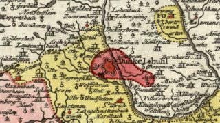
English: Detail cropped from a mid-18th century map showing the territory of the Free Imperial City of Dinkelsbühl, tucked in between the Principality of Oettingen (in yellow) and the Margraviate of Ansbach. Cropped out of map two of a multi-map series centered on the Circle of Swabia titled Per Inclyti Circuli Suevici Supremorum Ordinum, etc. published by Augsburg publisher Johann Andreas Pfeffel in 1746. |
| Date | |
| Source | Moll's map collection |
| Author | Johann Andreas Pfeffel |
Licensing[edit]
|
This work is in the public domain in its country of origin and other countries and areas where the copyright term is the author's life plus 100 years or fewer. | |
| This file has been identified as being free of known restrictions under copyright law, including all related and neighboring rights. | |
File history
Click on a date/time to view the file as it appeared at that time.
| Date/Time | Thumbnail | Dimensions | User | Comment | |
|---|---|---|---|---|---|
| current | 01:26, 30 August 2018 | | 1,920 × 1,079 (3.72 MB) | Lubiesque (talk | contribs) | User created page with UploadWizard |
You cannot overwrite this file.
File usage on Commons
There are no pages that use this file.