File:Relief-Archangelskaya.png
Jump to navigation
Jump to search

Size of this preview: 342 × 599 pixels. Other resolutions: 137 × 240 pixels | 472 × 827 pixels.
Original file (472 × 827 pixels, file size: 816 KB, MIME type: image/png)
Captions
Captions
Add a one-line explanation of what this file represents
Summary[edit]
| Description |
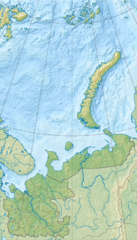
Русский: Физическая карта Архангельской области, включая Ненецкий автономный округ, Новая Земля, Земля Франца-Иосифа.
|
| Date | |
| Source |
|
| Author | Nzeemin |
| Other versions |
|

Licensing[edit]
| Description |
This map was created from OpenStreetMap project data, collected by the community. This map may be incomplete, and may contain errors. Don't rely solely on it for navigation. |
| Date | (see file history) |
| Source | openstreetmap.org |
| Creator |
OpenStreetMap contributors |
| Permission (Reusing this file) |
OpenStreetMap data and maps are licensed under the Creative Commons Attribution-ShareAlike 2.0 license (CC-BY-SA 2.0). This file is licensed under the Creative Commons Attribution-Share Alike 2.0 Generic license.
|
| Georeferencing | If inappropriate please set warp_status = skip to hide. |
File history
Click on a date/time to view the file as it appeared at that time.
| Date/Time | Thumbnail | Dimensions | User | Comment | |
|---|---|---|---|---|---|
| current | 19:09, 5 March 2012 | | 472 × 827 (816 KB) | Nzeemin (talk | contribs) |
You cannot overwrite this file.
File usage on Commons
The following page uses this file:
File usage on other wikis
The following other wikis use this file:
- Usage on ar.wikipedia.org
- Usage on arz.wikipedia.org
- Usage on azb.wikipedia.org
- Usage on az.wikipedia.org
- Usage on ba.wikipedia.org
- Usage on be.wikipedia.org
- Паўночны востраў (Новая Зямля)
- Калгуеў
- Матачкін Шар
- Паўднёвы востраў (Новая Зямля)
- Вікторыя (востраў, Расія)
- Зямля Франца-Іосіфа
- Шаблон:На карце/Расія Архангельская вобласць
- Пячорская губа
- Мязенская губа
- Анежская губа
- Вычагда
- Мязень (рака)
- Зямля Георга
- Анега (рака)
- Пінега
- Кулой (рака, упадае ў Белае мора)
- Лача
- Канін (паўвостраў)
- Зямля Вільчака
- Адзьва
- Зямля Аляксандры
- Usage on bg.wikipedia.org
View more global usage of this file.