File:Republic of China LCC administrative map Kuangtung.svg
Jump to navigation
Jump to search

Size of this PNG preview of this SVG file: 512 × 428 pixels. Other resolutions: 287 × 240 pixels | 574 × 480 pixels | 919 × 768 pixels | 1,225 × 1,024 pixels | 2,450 × 2,048 pixels.
Original file (SVG file, nominally 512 × 428 pixels, file size: 8.51 MB)
Captions
Captions
Add a one-line explanation of what this file represents
Summary
[edit]| Description |
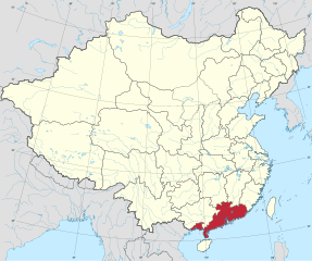
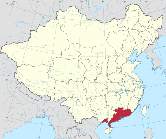
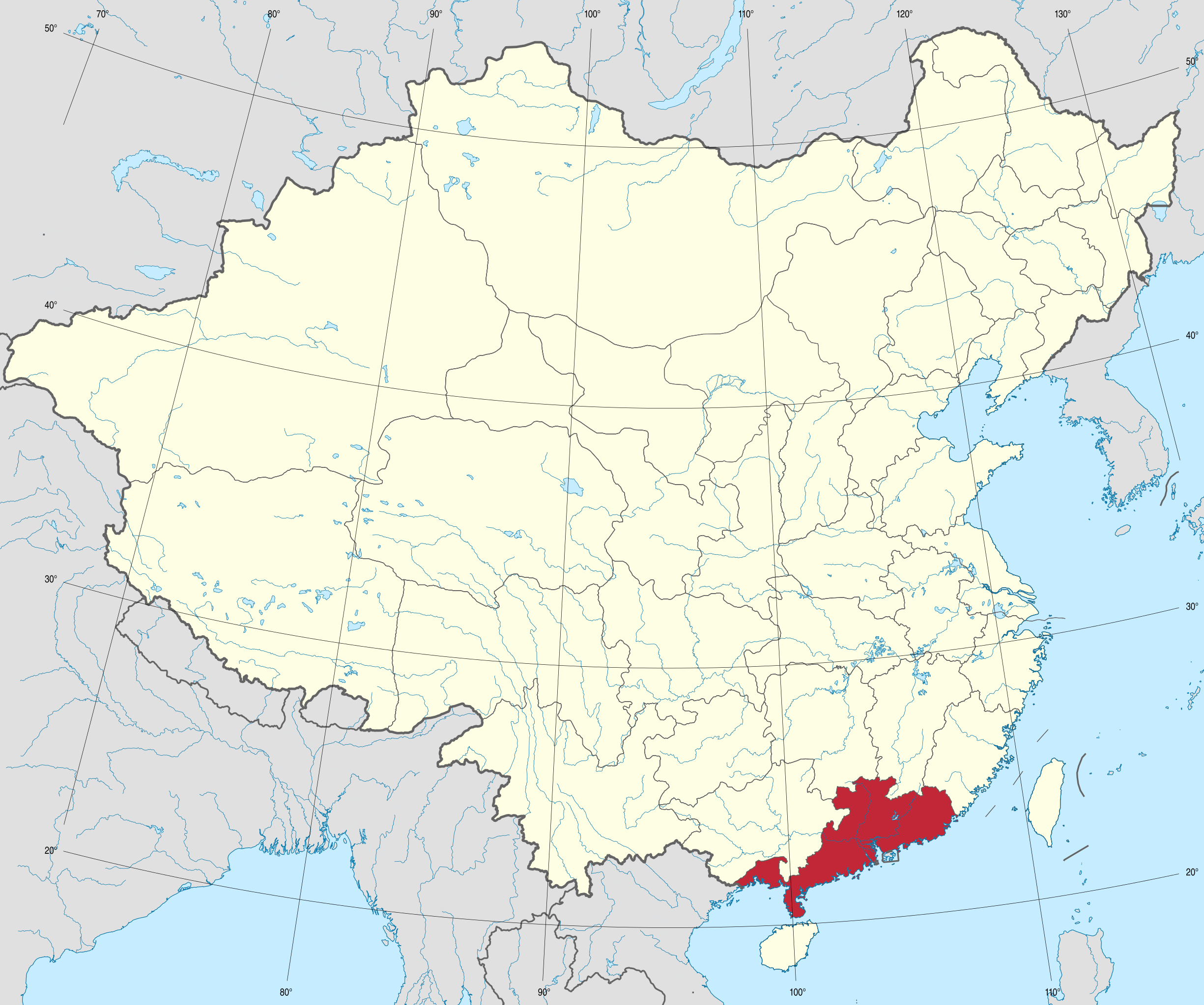
中華民國廣東省在中華民國的位置 中華民國廣東省
中華民國 |
||||||||||||
| Date | |||||||||||||
| Source | 中華民國行政區劃圖 | ||||||||||||
| Author | Lilauid | ||||||||||||
| Other versions |
Administrative division map of the Republic of China "Complete Map of the Republic of China" attached to "Records of the Sixth Session of the First National Assembly"
|
||||||||||||
.svg)
.svg)

.svg)


.svg)


.svg)


_Hainan.svg)
_Kuangtung.svg)
_Tibet_Area.svg)
_Mongolia_Area.svg)
_Sinkiang.svg)
_Kiangsu.svg)
_Chekiang.svg)
_Anhwei.svg)
_Kiangsi.svg)
_Hupeh.svg)
_Hunan.svg)
_Szechwan.svg)
_Fukien_(1912-1949).svg)
_Taiwan.svg)
_Kwangsi.svg)
_Yunnan.svg)
_Kweichow.svg)
_Hopeh.svg)
_Shantung.svg)
_Honan.svg)
_Shansi.svg)
_Shensi.svg)
_Kansu.svg)
_Ningsia.svg)
_Suiy%C3%BCan.svg)
_Chahar.svg)
_Jehol.svg)
_Liaoning.svg)
_Antung.svg)
_Liaopeh.svg)
_Kirin.svg)
_Sungkiang.svg)
_Hokiang.svg)
_Heilungkiang.svg)
_Nunkiang.svg)
_Hsingan.svg)
_Sikang.svg)
_Tsinghai.svg)
Licensing
[edit]
I, the copyright holder of this work, hereby publish it under the following license:
This file is licensed under the Creative Commons Attribution-Share Alike 4.0 International license.
- You are free:
- to share – to copy, distribute and transmit the work
- to remix – to adapt the work
- Under the following conditions:
- attribution – You must give appropriate credit, provide a link to the license, and indicate if changes were made. You may do so in any reasonable manner, but not in any way that suggests the licensor endorses you or your use.
- share alike – If you remix, transform, or build upon the material, you must distribute your contributions under the same or compatible license as the original.
File history
Click on a date/time to view the file as it appeared at that time.
| Date/Time | Thumbnail | Dimensions | User | Comment | |
|---|---|---|---|---|---|
| current | 15:43, 8 May 2024 | | 512 × 428 (8.51 MB) | Lilauid (talk | contribs) | {{Information |Description=中華民國廣東省在中華民國的位置<br />{{legend|#a02828|中華民國廣東省}} {{legend|#FEFEE7|中華民國}} |Source=中華民國行政區劃圖 |Date=2024-05-08 |Author=Lilauid |Permission= |other_versions={{中華民國行政區劃地圖}} }} Category:SVG locator maps of provinces in the Republic of China (location map scheme) |
You cannot overwrite this file.
File usage on Commons
The following 86 pages use this file:
- File:Republic of China LCC administrative map.svg
- File:Republic of China LCC administrative map Anhwei.svg
- File:Republic of China LCC administrative map Antung.svg
- File:Republic of China LCC administrative map Chahar.svg
- File:Republic of China LCC administrative map Chekiang.svg
- File:Republic of China LCC administrative map Fukien (1912-1949).svg
- File:Republic of China LCC administrative map Hainan.svg
- File:Republic of China LCC administrative map Heilungkiang.svg
- File:Republic of China LCC administrative map Honan.svg
- File:Republic of China LCC administrative map Hopeh.svg
- File:Republic of China LCC administrative map Hopkiang.svg
- File:Republic of China LCC administrative map Hsingan.svg
- File:Republic of China LCC administrative map Hunan.svg
- File:Republic of China LCC administrative map Hupeh.svg
- File:Republic of China LCC administrative map Kansu.svg
- File:Republic of China LCC administrative map Kiangsi.svg
- File:Republic of China LCC administrative map Kiangsu.svg
- File:Republic of China LCC administrative map Kirin.svg
- File:Republic of China LCC administrative map Kuangsi.svg
- File:Republic of China LCC administrative map Kuangtung.svg
- File:Republic of China LCC administrative map Kweichow.svg
- File:Republic of China LCC administrative map Liaoning.svg
- File:Republic of China LCC administrative map Liaopei.svg
- File:Republic of China LCC administrative map Mongolia Area.svg
- File:Republic of China LCC administrative map Ninghsia.svg
- File:Republic of China LCC administrative map Nunkiang.svg
- File:Republic of China LCC administrative map Rehe.svg
- File:Republic of China LCC administrative map Shansi.svg
- File:Republic of China LCC administrative map Shantung.svg
- File:Republic of China LCC administrative map Shensi.svg
- File:Republic of China LCC administrative map Sikang.svg
- File:Republic of China LCC administrative map Sinkiang.svg
- File:Republic of China LCC administrative map Suiyuan.svg
- File:Republic of China LCC administrative map Sungkiang.svg
- File:Republic of China LCC administrative map Szechuan.svg
- File:Republic of China LCC administrative map Taiwan.svg
- File:Republic of China LCC administrative map Tibet Area.svg
- File:Republic of China LCC administrative map Tsinghai.svg
- File:Republic of China LCC administrative map Yunnan.svg
- File:Republic of China edcp location map.svg
- File:Republic of China edcp location map (Excluding Mongolia Area).svg
- File:Republic of China edcp location map (disputed territories).svg
- File:Republic of China edcp location map 1946-1953 (disputed territories).svg
- File:Republic of China edcp location map Anhwei.svg
- File:Republic of China edcp location map Antung.svg
- File:Republic of China edcp location map Chahar.svg
- File:Republic of China edcp location map Chekiang.svg
- File:Republic of China edcp location map Fukien (1912-1949).svg
- File:Republic of China edcp location map Hainan.svg
- File:Republic of China edcp location map Heilungkiang.svg
- File:Republic of China edcp location map Hokiang.svg
- File:Republic of China edcp location map Honan.svg
- File:Republic of China edcp location map Hopeh.svg
- File:Republic of China edcp location map Hsingan.svg
- File:Republic of China edcp location map Hunan.svg
- File:Republic of China edcp location map Hupeh.svg
- File:Republic of China edcp location map Jehol.svg
- File:Republic of China edcp location map Kansu.svg
- File:Republic of China edcp location map Kiangsi.svg
- File:Republic of China edcp location map Kiangsu.svg
- File:Republic of China edcp location map Kirin.svg
- File:Republic of China edcp location map Kuangtung.svg
- File:Republic of China edcp location map Kwangsi.svg
- File:Republic of China edcp location map Kweichow.svg
- File:Republic of China edcp location map Liaoning.svg
- File:Republic of China edcp location map Liaopeh.svg
- File:Republic of China edcp location map Mongolia Area.svg
- File:Republic of China edcp location map Ningsia.svg
- File:Republic of China edcp location map Nunkiang.svg
- File:Republic of China edcp location map Shansi.svg
- File:Republic of China edcp location map Shantung.svg
- File:Republic of China edcp location map Shensi.svg
- File:Republic of China edcp location map Sikang.svg
- File:Republic of China edcp location map Sinkiang.svg
- File:Republic of China edcp location map Suiyüan.svg
- File:Republic of China edcp location map Sungkiang.svg
- File:Republic of China edcp location map Szechwan.svg
- File:Republic of China edcp location map Taiwan.svg
- File:Republic of China edcp location map Tibet Area.svg
- File:Republic of China edcp location map Tsinghai.svg
- File:Republic of China edcp location map Yünnan.svg
- File:中華民國地理大區.svg
- File:中華民國時區.svg
- File:中華民國爭議領土.svg
- Template:中華民國行政區劃地圖
- Template:中華民國行政區劃地圖/存檔1