File:Restored habitats in Bulgaria’s Lake Atanasovsko.jpg

Original file (4,410 × 2,540 pixels, file size: 4.23 MB, MIME type: image/jpeg)
Captions
Captions
Summary[edit]
| Description |
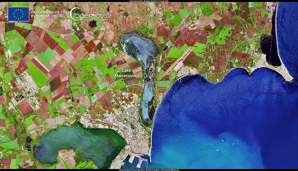
English: The Atanasovsko Lake, shown in this image acquired by one of the Copernicus Sentinel-2 satellites on 16 June 2022, is part of the Burgas lakes complex, one of the three most significant wetlands for congregations of waterfowl along the Bulgarian Black Sea coast. It is home to unique biodiversity and became a Natura2000 site in 2006. A disastrous flood which happened in 2010 destroyed water management facilities in the Atanasovsko Lake area, changing its hydrological and hydro-chemical conditions and disrupting the local environment. The Salt of Life Project, started in 2012, successfully contributed to the restoration of a satisfactory conservation status of the coastal lagoon habitat of the Atanasovsko Lake, for the benefit of the targeted bird species who have now repopulated the area. The data provided by the Copernicus Sentinel satellites and thematic services make it possible to extract vital information on the state of implementation of European policies, including those relating to the monitoring of water quality and the protection of critical biodiversity sites. |
| Date | Taken on 16 June 2022 |
| Source | Restored habitats in Bulgaria’s Lake Atanasovsko |
| Author | European Union, Copernicus Sentinel-2 imagery |
Licensing[edit]

|
This image contains data from a satellite in the Copernicus Programme, such as Sentinel-1, Sentinel-2 or Sentinel-3. Attribution is required when using this image.
Attribution: Contains modified Copernicus Sentinel data 2022
The use of Copernicus Sentinel Data is regulated under EU law (Commission Delegated Regulation (EU) No 1159/2013 and Regulation (EU) No 377/2014). Relevant excerpts:
Free access shall be given to GMES dedicated data [...] made available through GMES dissemination platforms [...].
Access to GMES dedicated data [...] shall be given for the purpose of the following use in so far as it is lawful:
GMES dedicated data [...] may be used worldwide without limitations in time.
GMES dedicated data and GMES service information are provided to users without any express or implied warranty, including as regards quality and suitability for any purpose. |
File history
Click on a date/time to view the file as it appeared at that time.
| Date/Time | Thumbnail | Dimensions | User | Comment | |
|---|---|---|---|---|---|
| current | 16:32, 20 August 2023 | | 4,410 × 2,540 (4.23 MB) | OptimusPrimeBot (talk | contribs) | #Spacemedia - Upload of https://www.copernicus.eu/system/files/2022-06/image_day/20220618_LakeAtanasovskoBulgaria.jpg via Commons:Spacemedia |
You cannot overwrite this file.
File usage on Commons
There are no pages that use this file.