File:Rheinuebung Karte.png
Jump to navigation
Jump to search

Size of this preview: 800 × 487 pixels. Other resolutions: 320 × 195 pixels | 640 × 389 pixels | 909 × 553 pixels.
Original file (909 × 553 pixels, file size: 36 KB, MIME type: image/png)
Captions
Captions
Add a one-line explanation of what this file represents
| Description |
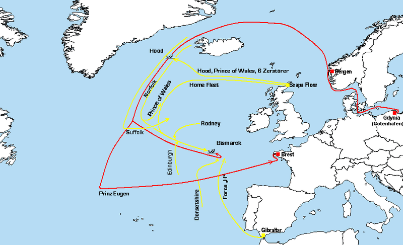
English: Map of the movements of the German (red) and British (yellow) ships during Operation Rheinübung, an attempted commerce raiding operation conducted by the battleship Bismarck in May 1941.
Deutsch: Karte mit den Kursen während der Unternehmung "Rheinübung"
Erstellt auf Grundlage eines Kartenausschnittes aus file:A large blank world map with oceans marked in blue.PNG aus Commons. (Die eingezeichneten Landesgrenzen entsprechen der Gegenwart, nicht der Situation von 1940). Sichtmeldung der Hood an die Admiralität war : 63,20N 31,5W |
| Date | 06.06.07 |
| Source | Own work |
| Author | WerWil |
| Other versions |
 |
I, the copyright holder of this work, hereby publish it under the following licenses:

|
Permission is granted to copy, distribute and/or modify this document under the terms of the GNU Free Documentation License, Version 1.2 or any later version published by the Free Software Foundation; with no Invariant Sections, no Front-Cover Texts, and no Back-Cover Texts. A copy of the license is included in the section entitled GNU Free Documentation License. |
| This file is licensed under the Creative Commons Attribution-Share Alike 3.0 Unported license. | ||
| ||
| This licensing tag was added to this file as part of the GFDL licensing update. |
This file is licensed under the Creative Commons Attribution-Share Alike 2.5 Generic, 2.0 Generic and 1.0 Generic license.
- You are free:
- to share – to copy, distribute and transmit the work
- to remix – to adapt the work
- Under the following conditions:
- attribution – You must give appropriate credit, provide a link to the license, and indicate if changes were made. You may do so in any reasonable manner, but not in any way that suggests the licensor endorses you or your use.
- share alike – If you remix, transform, or build upon the material, you must distribute your contributions under the same or compatible license as the original.
You may select the license of your choice.
File history
Click on a date/time to view the file as it appeared at that time.
| Date/Time | Thumbnail | Dimensions | User | Comment | |
|---|---|---|---|---|---|
| current | 15:06, 2 January 2008 | | 909 × 553 (36 KB) | Pibwl (talk | contribs) | |
| 16:55, 7 June 2007 |  | 909 × 553 (46 KB) | WerWil (talk | contribs) | {{Information |Description=Karte mit den Kursen während der Unternehmung "Rheinübung" Erstellt auf Grundlage eines Kartenausschnittes aus [A large blank world map with oceans marked in blue.PNG] aus Commons |Source=self-made |Date=06.06.07 |Author= [[Us | |
| 21:36, 6 June 2007 |  | 901 × 543 (24 KB) | WerWil (talk | contribs) | {{Information |Description=Karte mit den Kursen während der Unternehmung "Rheinübung" Erstellt auf Grundlage eines Kartenausschnittes aus [A large blank world map with oceans marked in blue.PNG] aus Commons |Source=self-made |Date=06.06.07 |Author= [[Us |
You cannot overwrite this file.
File usage on Commons
The following 2 pages use this file:
File usage on other wikis
The following other wikis use this file:
- Usage on de.wikipedia.org
- Usage on es.wikipedia.org
- Usage on eu.wikipedia.org
- Usage on hu.wikipedia.org
- Usage on it.wikipedia.org
- Usage on ksh.wikipedia.org
- Usage on nl.wikipedia.org
- Usage on simple.wikipedia.org