File:River Kennet between Avebury and Silbury Hill - geograph.org.uk - 282009.jpg
Jump to navigation
Jump to search
No higher resolution available.
River_Kennet_between_Avebury_and_Silbury_Hill_-_geograph.org.uk_-_282009.jpg (640 × 480 pixels, file size: 115 KB, MIME type: image/jpeg)
Captions
Captions
Add a one-line explanation of what this file represents
Summary[edit]
| Description |
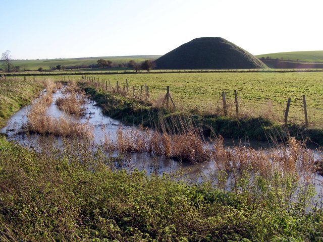
English: River Kennet between Avebury and Silbury Hill The muddy bridleway from Avebury to the Silbury Hill car park runs along the eastern bank of the River Kennet, which is a large stream at this point. The shady side of Silbury Hill can be seen across the water meadow and the West Kennett long barrow is visible as a long dark shadow on the ridge in the distance, towards the left of the photo. The Ordnance Survey map labels the river as ending in a single "t" (Kennet) whereas the surrounding placenames that incorporate the name end in a double "t" (West Kennett). |
| Date | |
| Source | From geograph.org.uk |
| Author | Jim Champion |
| Attribution (required by the license) | Jim Champion / River Kennet between Avebury and Silbury Hill / |
| Object location | | View this and other nearby images on: OpenStreetMap |
|---|
_heading:180.00&language=en)
Licensing[edit]

|
This image was taken from the Geograph project collection. See this photograph's page on the Geograph website for the photographer's contact details. The copyright on this image is owned by Jim Champion and is licensed for reuse under the Creative Commons Attribution-ShareAlike 2.0 license.
|
This file is licensed under the Creative Commons Attribution-Share Alike 2.0 Generic license.
Attribution: Jim Champion
- You are free:
- to share – to copy, distribute and transmit the work
- to remix – to adapt the work
- Under the following conditions:
- attribution – You must give appropriate credit, provide a link to the license, and indicate if changes were made. You may do so in any reasonable manner, but not in any way that suggests the licensor endorses you or your use.
- share alike – If you remix, transform, or build upon the material, you must distribute your contributions under the same or compatible license as the original.
- Remove redundant categories and try to put this image in the most specific category/categories
- Remove this template
- The location categories are based on information from this geonames tool and this OpenStreetMap tool combined with a database. You can also have a look at this tool from mysociety.
- The topic category from Geograph was River (find similar images at Geograph)
File history
Click on a date/time to view the file as it appeared at that time.
| Date/Time | Thumbnail | Dimensions | User | Comment | |
|---|---|---|---|---|---|
| current | 19:54, 14 December 2010 | | 640 × 480 (115 KB) | GeographBot (talk | contribs) | == {{int:filedesc}} == {{Information |description={{en|1=River Kennet between Avebury and Silbury Hill The muddy bridleway from Avebury to the Silbury Hill car park runs along the eastern bank of the River Kennet, which is a large stream at this point. Th |
You cannot overwrite this file.
File usage on Commons
There are no pages that use this file.
File usage on other wikis
The following other wikis use this file:
- Usage on en.wikipedia.org