File:SDUK - Turkey II. Containing the Northern Part of Greece.jpg
Jump to navigation
Jump to search

Size of this preview: 800 × 544 pixels. Other resolutions: 320 × 217 pixels | 640 × 435 pixels | 1,024 × 696 pixels | 1,280 × 870 pixels | 2,560 × 1,739 pixels | 5,764 × 3,916 pixels.
Original file (5,764 × 3,916 pixels, file size: 3.96 MB, MIME type: image/jpeg)
Captions
Captions
Add a one-line explanation of what this file represents
Summary[edit]
| Description |
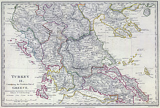
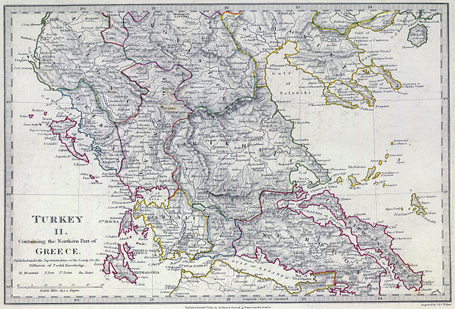
English: The southern provinces of European Turkey (Ottoman Empire) in 1829, including the northern portions of independent Greece (not differentiated in this map, which shows the pre-Greek War of Independence administrative boundaries). Published under the superintendence of the Society for the Diffusion of Useful Knowledge. |
| Date | |
| Source | David Rumsey Historical Map Collection |
| Author | Engraved by J. & C. Walker. Published September 1st. 1829 by Baldwin & Cradock, 47 Paternoster Row, London. (London: Chapman & Hall, 1844) |
Licensing[edit]
|
This work is in the public domain in its country of origin and other countries and areas where the copyright term is the author's life plus 100 years or fewer. | |
| This file has been identified as being free of known restrictions under copyright law, including all related and neighboring rights. | |
File history
Click on a date/time to view the file as it appeared at that time.
| Date/Time | Thumbnail | Dimensions | User | Comment | |
|---|---|---|---|---|---|
| current | 16:07, 12 February 2013 | | 5,764 × 3,916 (3.96 MB) | Cplakidas (talk | contribs) | User created page with UploadWizard |
You cannot overwrite this file.
File usage on Commons
There are no pages that use this file.
File usage on other wikis
The following other wikis use this file:
- Usage on bg.wikipedia.org
- Usage on ca.wikipedia.org
- Usage on el.wikipedia.org
- Usage on en.wikipedia.org
- Usage on fr.wikipedia.org
- Usage on it.wikipedia.org
- Usage on mk.wikipedia.org
- Usage on ru.wikipedia.org
- Usage on sq.wikipedia.org
- Usage on tr.wikipedia.org