File:SF Bay Rail Transit.svg
Jump to navigation
Jump to search

Size of this PNG preview of this SVG file: 800 × 596 pixels. Other resolutions: 320 × 239 pixels | 640 × 477 pixels | 1,024 × 763 pixels | 1,280 × 954 pixels | 2,560 × 1,909 pixels | 2,362 × 1,761 pixels.
Original file (SVG file, nominally 2,362 × 1,761 pixels, file size: 3.02 MB)
Captions
Captions
Add a one-line explanation of what this file represents
Summary[edit]
| Description |
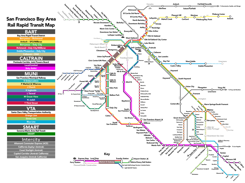
English: Map of the rail transit systems in the San Francisco Bay Area. Entirely my own work except for the transit agency logos, which are trademarked but ineligible for copyright.
These are the logos used: File:Bart-logo.svg, File:Caltrain logo.svg, File:Amtrak logo.svg, File:Altamont Commuter Express (logo).png, File:BSicon LOGO SFmuni.svg, and File:Santa Clara VTA logo.svg. |
| Date | |
| Source | Own work |
| Author | Haha169 |
.png)
Licensing[edit]
I, the copyright holder of this work, hereby publish it under the following license:
This file is licensed under the Creative Commons Attribution-Share Alike 3.0 Unported license.
- You are free:
- to share – to copy, distribute and transmit the work
- to remix – to adapt the work
- Under the following conditions:
- attribution – You must give appropriate credit, provide a link to the license, and indicate if changes were made. You may do so in any reasonable manner, but not in any way that suggests the licensor endorses you or your use.
- share alike – If you remix, transform, or build upon the material, you must distribute your contributions under the same or compatible license as the original.

|
This work includes material that may be protected as a trademark in some jurisdictions. If you want to use it, you have to ensure that you have the legal right to do so and that you do not infringe any trademark rights. See our general disclaimer. This tag does not indicate the copyright status of the attached work. A normal copyright tag is still required. See Commons:Licensing. |
File history
Click on a date/time to view the file as it appeared at that time.
| Date/Time | Thumbnail | Dimensions | User | Comment | |
|---|---|---|---|---|---|
| current | 19:46, 3 July 2023 | | 2,362 × 1,761 (3.02 MB) | Haha169 (talk | contribs) | various june 2023 updates (sfo lines/T-Chinatown) and fixes (redo ebart transfer) |
| 20:47, 15 June 2020 |  | 2,362 × 1,761 (3.05 MB) | Haha169 (talk | contribs) | minor fixes | |
| 02:35, 15 June 2020 |  | 2,362 × 1,761 (3.04 MB) | Haha169 (talk | contribs) | Updates - June 2020 | |
| 06:41, 18 August 2017 |  | 2,362 × 1,761 (3.05 MB) | Haha169 (talk | contribs) | add E&F heritage streetcar and other fixes | |
| 20:13, 11 August 2017 |  | 2,362 × 1,761 (2.96 MB) | Haha169 (talk | contribs) | ferry fixes | |
| 19:57, 11 August 2017 |  | 2,362 × 1,761 (2.96 MB) | Haha169 (talk | contribs) | minor changes and fixes | |
| 04:07, 11 August 2017 |  | 2,362 × 1,761 (2.86 MB) | Haha169 (talk | contribs) | Update situation with new station openings and routes/redraw map | |
| 03:23, 16 July 2016 |  | 1,000 × 1,000 (2.71 MB) | Haha169 (talk | contribs) | minor fixes | |
| 18:07, 12 August 2013 |  | 1,000 × 1,000 (2.71 MB) | Haha169 (talk | contribs) | Better spacing and arrangement, cleanup | |
| 16:55, 4 August 2013 |  | 1,835 × 2,350 (1.03 MB) | Haha169 (talk | contribs) | Cleanup |
You cannot overwrite this file.
File usage on Commons
The following 12 pages use this file:
- User:Chumwa/OgreBot/Potential transport maps/2016 July 11-20
- User:Chumwa/OgreBot/Potential transport maps/2017 August 11-20
- User:Chumwa/OgreBot/Public transport information/2016 July 11-20
- User:Chumwa/OgreBot/Public transport information/2017 August 11-20
- User:Chumwa/OgreBot/Public transport information/2020 June 11-20
- User:Chumwa/OgreBot/Transport Maps/2016 July 11-20
- User:Chumwa/OgreBot/Transport Maps/2017 August 11-20
- User:Chumwa/OgreBot/Transport Maps/2020 June 11-20
- User:Chumwa/OgreBot/Transport Maps/2023 July 1-10
- User:Chumwa/OgreBot/Travel and communication maps/2016 July 11-20
- User:Chumwa/OgreBot/Travel and communication maps/2017 August 11-20
- User:Chumwa/OgreBot/Travel and communication maps/2020 June 11-20
File usage on other wikis
The following other wikis use this file:
- Usage on en.wikipedia.org
- Usage on en.wikivoyage.org
- Usage on hu.wikipedia.org
- Usage on zh.wikipedia.org