File:Saarland location map G.svg
Jump to navigation
Jump to search

Size of this PNG preview of this SVG file: 658 × 540 pixels. Other resolutions: 293 × 240 pixels | 585 × 480 pixels | 936 × 768 pixels | 1,248 × 1,024 pixels | 2,496 × 2,048 pixels.
Original file (SVG file, nominally 658 × 540 pixels, file size: 192 KB)
Captions
Captions
Add a one-line explanation of what this file represents
| Description |
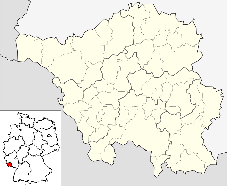
English: Position map of the state of Saarland, showing position of Saarland within Germany with the six disticts and fiftytwo municipalities
Geographic limits of the map: * N: 49.65° N * S: 49.09° N * W: 6.3° E * E: 7.405° E Deutsch: Positionskarte vom Bundesland Saarland, einschl. der Lage innerhalb Deutschlands, mit seinen sechs Kreisen und 52 Gemeinden Quadratische Plattkarte. Geographische Begrenzung der Karte: * N: 49.65° N * S: 49.09° N * W: 6.3° E * E: 7.405° E |
| Date | |
| Source | own work based on File:Saarland location map.svg |
| Author | Hanhil based on work by Lantus |
Licensing[edit]
I, the copyright holder of this work, hereby publish it under the following license:
This file is licensed under the Creative Commons Attribution-Share Alike 3.0 Unported license.
- You are free:
- to share – to copy, distribute and transmit the work
- to remix – to adapt the work
- Under the following conditions:
- attribution – You must give appropriate credit, provide a link to the license, and indicate if changes were made. You may do so in any reasonable manner, but not in any way that suggests the licensor endorses you or your use.
- share alike – If you remix, transform, or build upon the material, you must distribute your contributions under the same or compatible license as the original.
File history
Click on a date/time to view the file as it appeared at that time.
| Date/Time | Thumbnail | Dimensions | User | Comment | |
|---|---|---|---|---|---|
| current | 23:12, 30 May 2009 | | 658 × 540 (192 KB) | Michiel1972 (talk | contribs) | frame |
| 08:55, 22 May 2009 |  | 658 × 540 (188 KB) | Hanhil (talk | contribs) | {{Information |Description={{en|1=Position map of the state of Saarland, showing position of Saarland within Germany with the six disticts and fiftytwo municipalities<br> Geographic limits of the map: * N: 49.65° N * S: 49.09° N * W: 6.3 |
You cannot overwrite this file.
File usage on Commons
The following page uses this file:
File usage on other wikis
The following other wikis use this file:
- Usage on de.wikivoyage.org
- Usage on fa.wikipedia.org
- Usage on ja.wikipedia.org
- Usage on ka.wikipedia.org
- Usage on ko.wikipedia.org
- Usage on no.wikipedia.org
- Usage on pl.wikipedia.org
- Saarbrücken
- Neunkirchen (Saara)
- Port lotniczy Saarbrücken
- Huta żelaza w Völklingen
- Saarbrücken Hauptbahnhof
- Dillingen/Saar
- Merzig
- Wadern
- Merzig (Saar)
- Merzig (Saar) Stadtmitte
- Saarbrücken-Burbach
- St. Wendel
- Ottweiler
- Homburg (Saar) Hauptbahnhof
- St. Ingbert
- Homburg
- Saarlouis
- Friedrichsthal
- St. Ingbert (stacja kolejowa)
- Beckingen (stacja kolejowa)
- Völklingen
- Lebach
- Bethingen
- Dreisbach (Mettlach)
- Faha
- Weiten (Mettlach)
- Nohn (Mettlach)
- Püttlingen
- Bexbach
- Orscholz
- Saarhölzbach (Mettlach)
- Tünsdorf
- Wehingen (Mettlach)
- Uniwersytet Kraju Saary
- Blieskastel
- Szablon:Państwo dane Saara
- Sulzbach/Saar
- Karlsberg Brauerei
- Lotnisko Saarlouis-Düren
View more global usage of this file.