File:SaoPaulo-Landsat-2.jpg
SaoPaulo-Landsat-2.jpg (400 × 400 pixels, file size: 65 KB, MIME type: image/jpeg)
Captions
Captions

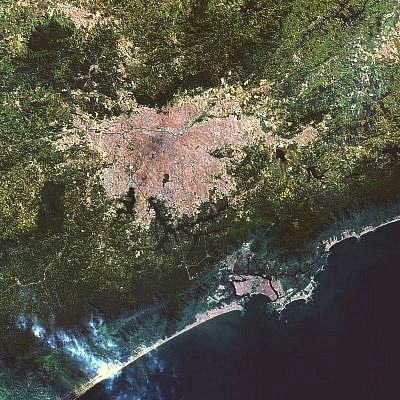
Uma imagem do satélite Landsat em que se vê região metropolitana da Grande São Paulo (mancha cinzenta no centro da foto) e a Região Metropolitana da Baixada Santista Originalmente carregada na Wikipédia anglófona em w:Image:Sao Paulo Landsat.jpg.
.svg)
A Landsat image of the Greater São Paulo metropolitan area (gray spot at the center) and the Metropolitan Region Baixada Santista with the harbour of Santos. Originally uploaded in the English Wikipedia at w:Image:Sao Paulo Landsat.jpg.
This image is a modified version of São Paulo Landsat (fotografia de satélite).jpg
.jpg)
| This file is in the public domain in the United States because it was solely created by NASA. NASA copyright policy states that "NASA material is not protected by copyright unless noted". (See Template:PD-USGov, NASA copyright policy page or JPL Image Use Policy.) | ||
 |
Warnings:
|
File history
Click on a date/time to view the file as it appeared at that time.
| Date/Time | Thumbnail | Dimensions | User | Comment | |
|---|---|---|---|---|---|
| current | 12:09, 30 May 2010 | | 400 × 400 (65 KB) | OAlexander~commonswiki (talk | contribs) | {{Information |Description= |Source= |Date= |Author= |Permission= |other_versions= }} |
| 23:59, 8 January 2009 |  | 400 × 400 (49 KB) | OAlexander~commonswiki (talk | contribs) | 20px|left Uma imagem do satélite Landsat em que se vê região metropolitana da Grande São Paulo (mancha cinzenta no centro da foto) e a Região Metropolitana da Baixada Santista Originalmente carregada na Wikip |
You cannot overwrite this file.
File usage on Commons
There are no pages that use this file.
File usage on other wikis
The following other wikis use this file:
- Usage on de.wikipedia.org
- Usage on de.wikivoyage.org
- Usage on es.wikipedia.org