File:Saxony after the Capitulation of Wittenberg (1547) - NL.png
Jump to navigation
Jump to search

Size of this preview: 800 × 538 pixels. Other resolutions: 320 × 215 pixels | 640 × 430 pixels | 1,024 × 688 pixels | 1,280 × 861 pixels | 2,875 × 1,933 pixels.
Original file (2,875 × 1,933 pixels, file size: 1.63 MB, MIME type: image/png)
Captions
Captions
Add a one-line explanation of what this file represents
Summary
[edit]| Description |
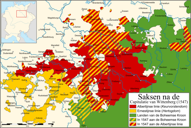
English: Map of Saxony after the Capitulation of Wittenberg (1547). Dutch version
Nederlands: Kaart van Saksen na de Capitulatie van Wittenberg (1547). Nederlandse versie. |
| Date | |
| Source | Own work, based on Perthes Atlas Geschichte |
| Author | Sir Iain |
| Other versions | Derivative works of this file: Saxony after the Capitulation of Wittenberg (1547) - DE.png |

_-_NL.png&action=edit§ion=1)
_-_DE.png)
Licensing
[edit]_-_NL.png&action=edit§ion=2)
I, the copyright holder of this work, hereby publish it under the following licenses:
This file is licensed under the Creative Commons Attribution-Share Alike 3.0 Unported license.
- You are free:
- to share – to copy, distribute and transmit the work
- to remix – to adapt the work
- Under the following conditions:
- attribution – You must give appropriate credit, provide a link to the license, and indicate if changes were made. You may do so in any reasonable manner, but not in any way that suggests the licensor endorses you or your use.
- share alike – If you remix, transform, or build upon the material, you must distribute your contributions under the same or compatible license as the original.

|
Permission is granted to copy, distribute and/or modify this document under the terms of the GNU Free Documentation License, Version 1.2 or any later version published by the Free Software Foundation; with no Invariant Sections, no Front-Cover Texts, and no Back-Cover Texts. A copy of the license is included in the section entitled GNU Free Documentation License. |
You may select the license of your choice.
File history
Click on a date/time to view the file as it appeared at that time.
| Date/Time | Thumbnail | Dimensions | User | Comment | |
|---|---|---|---|---|---|
| current | 18:44, 17 April 2010 | | 2,875 × 1,933 (1.63 MB) | Sir Iain (talk | contribs) | {{Information |Description={{en|1=Map of Saxony after the Capitulation of Wittenberg (1547). Dutch version}} {{nl|1=Kaart van Saksen na de Capitulatie van Wittenberg (1547). Nederlandse versie.}} |Source={{own}}, based on Perthes Atlas Geschichte |Author= |
You cannot overwrite this file.
File usage on Commons
The following 2 pages use this file:
_-_NL.png&redirect=no)
File usage on other wikis
The following other wikis use this file:
- Usage on ar.wikipedia.org
- Usage on cs.wikipedia.org
- Usage on da.wikipedia.org
- Usage on es.wikipedia.org
- Usage on fr.wikipedia.org
- Usage on he.wikipedia.org
- Usage on ja.wikipedia.org
- Usage on nl.wikipedia.org
- Usage on sv.wikipedia.org
_-_NL.png&oldid=905191455)