File:ScanEagle operators.png
Jump to navigation
Jump to search

Size of this preview: 800 × 407 pixels. Other resolutions: 320 × 163 pixels | 640 × 325 pixels | 1,024 × 521 pixels | 1,280 × 651 pixels | 2,753 × 1,400 pixels.
Original file (2,753 × 1,400 pixels, file size: 92 KB, MIME type: image/png)
Captions
Captions
Add a one-line explanation of what this file represents
Summary[edit]
| Description |
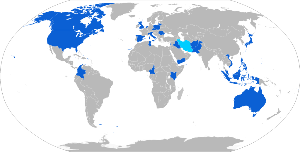
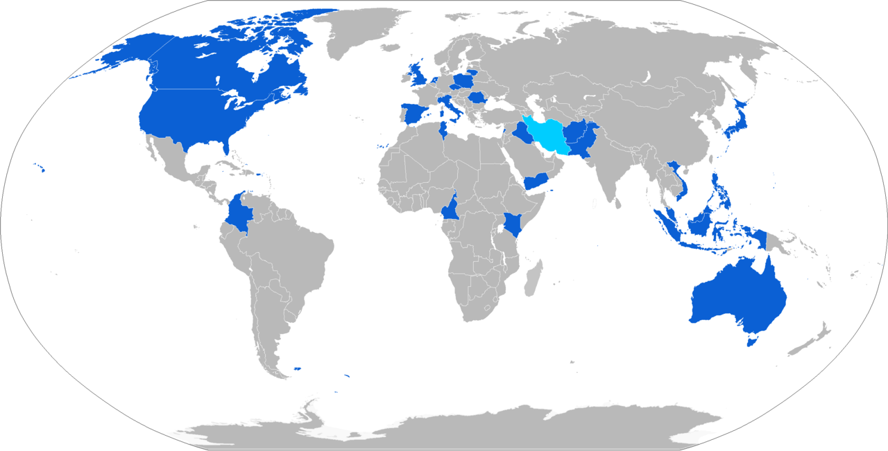
English: Map with ScanEagle operators in blue and operators of unlicensed reproductions in light blue |
| Date | |
| Source | Own work |
| Author | Jurryaany |

|
File:ScanEagle operators.svg is a vector version of this file. It should be used in place of this PNG file when not inferior.
File:ScanEagle operators.png → File:ScanEagle operators.svg
For more information, see Help:SVG. |
 |
Licensing[edit]
I, the copyright holder of this work, hereby publish it under the following license:
This file is licensed under the Creative Commons Attribution-Share Alike 4.0 International license.
- You are free:
- to share – to copy, distribute and transmit the work
- to remix – to adapt the work
- Under the following conditions:
- attribution – You must give appropriate credit, provide a link to the license, and indicate if changes were made. You may do so in any reasonable manner, but not in any way that suggests the licensor endorses you or your use.
- share alike – If you remix, transform, or build upon the material, you must distribute your contributions under the same or compatible license as the original.
File history
Click on a date/time to view the file as it appeared at that time.
| Date/Time | Thumbnail | Dimensions | User | Comment | |
|---|---|---|---|---|---|
| current | 09:44, 3 June 2019 | | 2,753 × 1,400 (92 KB) | Jurryaany (talk | contribs) | Added Vietnam |
| 22:59, 24 February 2018 |  | 2,753 × 1,400 (92 KB) | Jurryaany (talk | contribs) | Added Indonesia | |
| 15:32, 8 June 2017 |  | 2,753 × 1,400 (92 KB) | Jurryaany (talk | contribs) | Updated map | |
| 19:17, 6 July 2016 |  | 2,753 × 1,400 (92 KB) | Jurryaany (talk | contribs) | User created page with UploadWizard |
You cannot overwrite this file.
File usage on Commons
The following 16 pages use this file:
- User:Chumwa/OgreBot/Potential transport maps/2016 July 1-10
- User:Chumwa/OgreBot/Potential transport maps/2017 June 1-10
- User:Chumwa/OgreBot/Potential transport maps/2018 February 19-28
- User:Chumwa/OgreBot/Potential transport maps/2019 June 1-10
- User:Chumwa/OgreBot/Transport Maps/2016 July 1-10
- User:Chumwa/OgreBot/Transport Maps/2017 June 1-10
- User:Chumwa/OgreBot/Transport Maps/2018 February 19-28
- User:Chumwa/OgreBot/Transport Maps/2019 June 1-10
- User:Chumwa/OgreBot/Travel and communication maps/2016 July 1-10
- User:Chumwa/OgreBot/Travel and communication maps/2017 June 1-10
- User:Chumwa/OgreBot/Travel and communication maps/2018 February 19-28
- User:Chumwa/OgreBot/Travel and communication maps/2019 June 1-10
- Commons:WikiProject Aviation/recent uploads/2016 July 6
- Commons:WikiProject Aviation/recent uploads/2017 June 8
- Commons:WikiProject Aviation/recent uploads/2018 February 24
- Commons:WikiProject Aviation/recent uploads/2019 June 3
File usage on other wikis
The following other wikis use this file:
- Usage on ar.wikipedia.org
- Usage on it.wikipedia.org
- Usage on ja.wikipedia.org