File:Schlottmann House.jpg
Jump to navigation
Jump to search

Size of this preview: 800 × 600 pixels. Other resolutions: 320 × 240 pixels | 640 × 480 pixels | 1,024 × 768 pixels.
Original file (1,024 × 768 pixels, file size: 263 KB, MIME type: image/jpeg)
Captions
Captions
Add a one-line explanation of what this file represents
Summary
[edit]
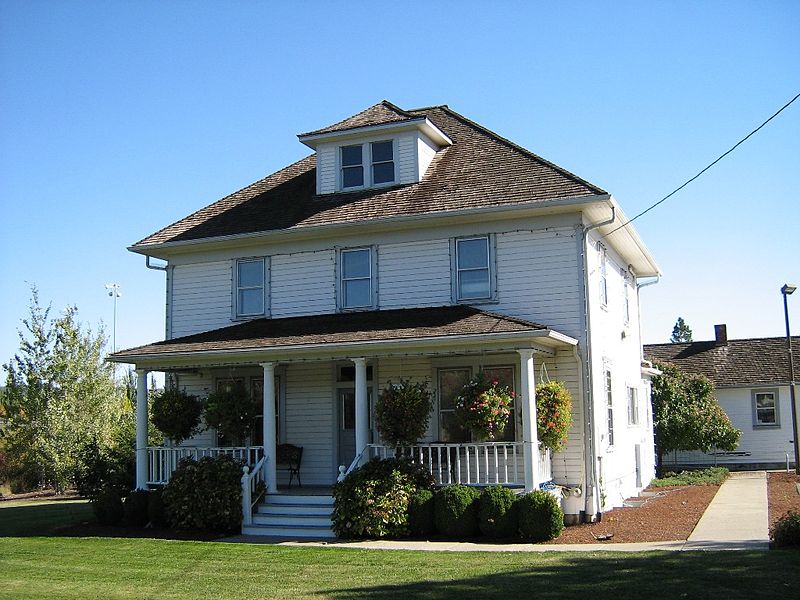
| Description | Heinrick Schlottmann immigrated to Oregon from Germany and settled his homestead on 97 acres. Heinrick and his family lived in a log house until construction of the frame house in 1906. A carpenter by trade, Heinrick built the house, including all interior woodwork and cabinetry, in a 20th Century American Four Square Style. Lumber used in construction was purchased from the Mountaindale Sawmill. It took five years to complete construction of the house. Oats, wheat, and hay were grown on the farm, as well as raising dairy cattle. The Schlottmann family owned and operated a mercantile store for many years located near the Elmonica Station (Oregon Electric Railroad). The station and the store, now removed, were located within yards of the existing rail crossing on Baseline Road. Heinrick's son, Emil, was born in 1890 and lived on this property for 92 years until his death in 1982. He and his wife, Emma, were married in 1945 and she lived on the farm for 42 years. They discontinued dairy farming after 1958. While Emil was still alive, the Schlottmann's sold 70 acres to the Tualatin Hills Park and Recreation District in the late 1970's. In 1988 the Park District acquired the Schlottmann main house, bunk house, and garage. Cornell Oaks Corporate Center owned the 27 acres of the original Schlottmann homestead. Washington County's Department of Land Use and Transportation conditioned them, that for development to take place on the site, the three buildings would need to be preserved either on or off the site. In 1992 the 27 acres owned by the Corporate Center were offered to the Park District for purchase. Today the house and bunk house are utilized as maintenance operations office space. |
| Date | |
| Source | Schlottmann House |
| Author | KaCey97078 from Aloha, OR, USA |
| Camera location | | View this and other nearby images on: OpenStreetMap |
|---|
Licensing
[edit]
This file is licensed under the Creative Commons Attribution 2.0 Generic license.
- You are free:
- to share – to copy, distribute and transmit the work
- to remix – to adapt the work
- Under the following conditions:
- attribution – You must give appropriate credit, provide a link to the license, and indicate if changes were made. You may do so in any reasonable manner, but not in any way that suggests the licensor endorses you or your use.
| This image was originally posted to Flickr by KaCey97078 at https://flickr.com/photos/37015070@N00/265433368. It was reviewed on 22 December 2015 by FlickreviewR and was confirmed to be licensed under the terms of the cc-by-2.0. |
File history
Click on a date/time to view the file as it appeared at that time.
| Date/Time | Thumbnail | Dimensions | User | Comment | |
|---|---|---|---|---|---|
| current | 19:21, 22 December 2015 | | 1,024 × 768 (263 KB) | Kingofthedead (talk | contribs) | Transferred from Flickr via Flickr2Commons |
You cannot overwrite this file.
File usage on Commons
There are no pages that use this file.
File usage on other wikis
The following other wikis use this file:
- Usage on en.wikipedia.org
- Usage on mdf.wikipedia.org