File:Sheffield Railways 2005.png
Jump to navigation
Jump to search

Size of this preview: 565 × 600 pixels. Other resolutions: 226 × 240 pixels | 452 × 480 pixels | 723 × 768 pixels | 964 × 1,024 pixels | 1,681 × 1,785 pixels.
Original file (1,681 × 1,785 pixels, file size: 207 KB, MIME type: image/png)
Captions
Captions
Add a one-line explanation of what this file represents
Summary[edit]
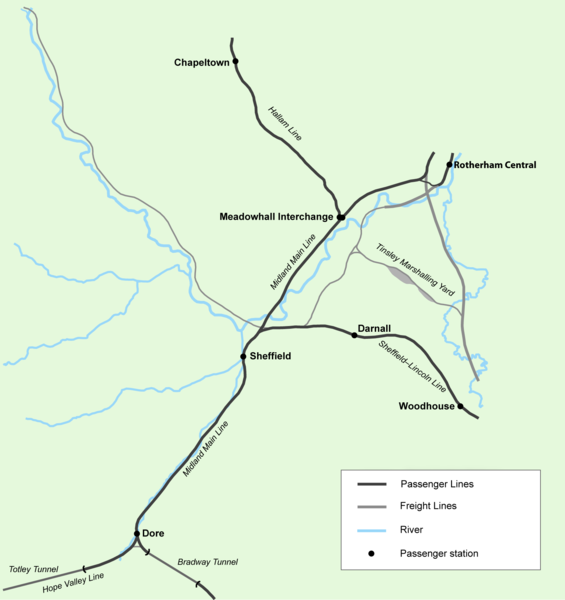
| Description | Railways in Sheffield, England as they were c.2005. |
| Date | |
| Source | Self made. Details were traced from a 1907 one inch to the mile Ordnance Survey map, 1855 Ordnance Survey maps, and satellite photographs from Google Earth. |
| Author | User:JeremyA |
| Permission (Reusing this file) |
Permission is granted for reuse under the terms of the below licence. The required attribution is: © 2006, Jeremy Atherton. Derivative works must use the same licence |
| Other versions | Image:Sheffield Railways 1855.png, Image:Sheffield Railways 1930.png |
Notes[edit]
Features that are the subject of wikipedia articles:
Railway stations
- w:Chapeltown railway station
- w:Darnall railway station
- w:Rotherham Central railway station
- W:Sheffield Midland railway station
- w:Woodhouse railway station
Railway lines
Licensing[edit]
I, the copyright holder of this work, hereby publish it under the following license:
This file is licensed under the Creative Commons Attribution-Share Alike 3.0 Unported license.
- You are free:
- to share – to copy, distribute and transmit the work
- to remix – to adapt the work
- Under the following conditions:
- attribution – You must give appropriate credit, provide a link to the license, and indicate if changes were made. You may do so in any reasonable manner, but not in any way that suggests the licensor endorses you or your use.
- share alike – If you remix, transform, or build upon the material, you must distribute your contributions under the same or compatible license as the original.
File history
Click on a date/time to view the file as it appeared at that time.
| Date/Time | Thumbnail | Dimensions | User | Comment | |
|---|---|---|---|---|---|
| current | 03:01, 3 May 2006 | | 1,681 × 1,785 (207 KB) | JeremyA (talk | contribs) | == Summary == Railways in Sheffield, England. The railways of Sheffield as they were c.2005. ==Notes== Details were traced from a 1907 one inch to the mile Ordnance Survey map, 1855 Ordnance Survey maps, and satellite photographs from Google Earth. |
You cannot overwrite this file.
File usage on Commons
The following page uses this file:
File usage on other wikis
The following other wikis use this file:
- Usage on en.wikipedia.org