File:Shire Lane, between Hastoe and Cholesbury - geograph.org.uk - 1201321.jpg
Jump to navigation
Jump to search

Size of this preview: 450 × 600 pixels. Other resolutions: 180 × 240 pixels | 480 × 640 pixels.
Original file (480 × 640 pixels, file size: 145 KB, MIME type: image/jpeg)
Captions
Captions
Add a one-line explanation of what this file represents
Summary[edit]
| Description |
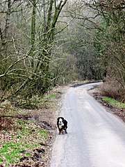
English: Shire Lane, between Hastoe and Cholesbury. Shire Lane forms the boundary of Hertfordshire (on the east) and Buckinghamshire (on the west) and may well have been a right of way when the county boundaries were agreed more than a thousand years ago. It is a tarmac road at this point but the ancient trackway can be followed north through Pavis Wood 576002 and Fox Lane 1199937 |
| Date | |
| Source | From geograph.org.uk |
| Author | Chris Reynolds |
| Attribution (required by the license) | Chris Reynolds / Shire Lane, between Hastoe and Cholesbury / |
| Camera location | | View this and other nearby images on: OpenStreetMap |
|---|
_heading:90.00&language=en)
| Object location | | View this and other nearby images on: OpenStreetMap |
|---|
_heading:90.00&language=en)
Licensing[edit]

|
This image was taken from the Geograph project collection. See this photograph's page on the Geograph website for the photographer's contact details. The copyright on this image is owned by Chris Reynolds and is licensed for reuse under the Creative Commons Attribution-ShareAlike 2.0 license.
|
This file is licensed under the Creative Commons Attribution-Share Alike 2.0 Generic license.
Attribution: Chris Reynolds
- You are free:
- to share – to copy, distribute and transmit the work
- to remix – to adapt the work
- Under the following conditions:
- attribution – You must give appropriate credit, provide a link to the license, and indicate if changes were made. You may do so in any reasonable manner, but not in any way that suggests the licensor endorses you or your use.
- share alike – If you remix, transform, or build upon the material, you must distribute your contributions under the same or compatible license as the original.
File history
Click on a date/time to view the file as it appeared at that time.
| Date/Time | Thumbnail | Dimensions | User | Comment | |
|---|---|---|---|---|---|
| current | 04:25, 26 February 2011 | | 480 × 640 (145 KB) | GeographBot (talk | contribs) | == {{int:filedesc}} == {{Information |description={{en|1=Shire Lane, between Hastoe and Cholesbury Shire Lane forms the boundary of Hertfordshire (on the east) and Buckinghamshire (on the west) and may well have been a right of way when the county boundar |
You cannot overwrite this file.
File usage on Commons
There are no pages that use this file.