File:Silvretta Hochalpenstraße 360° Panorama.jpg
Jump to navigation
Jump to search

Size of this preview: 799 × 173 pixels. Other resolutions: 320 × 69 pixels | 640 × 139 pixels | 1,024 × 222 pixels | 1,280 × 277 pixels | 8,067 × 1,748 pixels.
Original file (8,067 × 1,748 pixels, file size: 11.48 MB, MIME type: image/jpeg)
Captions
Captions
Add a one-line explanation of what this file represents
| Description |
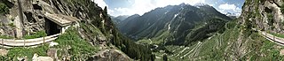
Deutsch: Untervermunt, 180°-Panorama. Vor dem Eingang des 1,5 km langen und begehbaren „Vermunt-Stollen“ der ehemaligen Höhenbahn Trominier–Vermunt, heute Wasser-Erlebnisstollen Vermunt, richtet sich der Blick auf die Silvretta-Hochalpenstraße. Vor den noch mit Schnee bedeckten Silvrettagruppe am rechten Bildrand (Hintere Lobspitze, Großer Litzner und das Große Seehorn) sieht man im Tal die Staumauer des Vermuntstausees. Die markante Spitze in der Bildmitte ist der 2277 Meter hohe Zaferna. |
| Date | |
| Source | Own work |
| Author | böhringer friedrich |
| Permission (Reusing this file) |
I, the copyright holder of this work, hereby publish it under the following license: This file is licensed under the Creative Commons Attribution-Share Alike 2.5 Generic license.
|
| 360° | View in 360° panoramic viewer
|
|---|
This Photo was taken by Böhringer Friedrich.
|
Feel free to use my photos, but please mention me as the author and if you want send me a message. or (rufre@lenz-nenning.at) |
| Camera location | | View this and other nearby images on: OpenStreetMap |
|---|
| Annotations | This image is annotated: View the annotations at Commons |
File history
Click on a date/time to view the file as it appeared at that time.
| Date/Time | Thumbnail | Dimensions | User | Comment | |
|---|---|---|---|---|---|
| current | 21:50, 26 June 2010 | 8,067 × 1,748 (11.48 MB) | Böhringer (talk | contribs) | {{Information |Description= {{de| Untervermunt, 360° Panorama. Vor dem Eingang des 1,5km langen und begehbaren "Vermunt Stollen" richtet sich der Blick auf die Silvretta Hochalpenstraße. Vor den noch mit Schnee bedeckt |
You cannot overwrite this file.
File usage on Commons
The following 2 pages use this file:
File usage on other wikis
The following other wikis use this file:
- Usage on de.wikipedia.org
- Usage on www.wikidata.org