File:Sinuous rille near Gruithuisen H (LRO) 3.png
From Wikimedia Commons, the free media repository
Jump to navigation
Jump to search
Sinuous_rille_near_Gruithuisen_H_(LRO)_3.png (336 × 252 pixels, file size: 64 KB, MIME type: image/png)
File information
Structured data
Captions
Captions
Add a one-line explanation of what this file represents
Summary[edit]
| DescriptionSinuous rille near Gruithuisen H (LRO) 3.png |
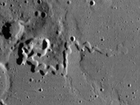
Українська: Звивиста борозна на Місяці, на західному краю Моря Дощів (на межі з Океаном Бур), біля кратера Груйтуйзен H (32,9° N, 37,6°W). Ймовірно, лава нею текла зліва направо (Hurwitz et al., 2013, p. 22). Знімок космічного апарата Lunar Reconnaissance Orbiter, зроблений ширококутньою камерою (WAC) 23 червня 2010 року з висоти 37,52 км. Висота Сонця — 5,7°. Ширина фото — 20 км, північ приблизно вгорі.
English: Sinuous rille on the Moon, on the western shore of Mare Imbrium (on the border with Oceanus Procellarum), near crater Gruithuisen H (32.9° N, 37.6°W). Probably, lava moved in it from left to right (Hurwitz et al., 2013, p. 22). Photo by Lunar Reconnaissance Orbiter, made with Wide Angle Camera on 23 June 2010 from altitude 37.52 km. Sun elevation is 5.7°. Width of the photo is 20 km, north is approximately up. |
| Date | |
| Source | Image M131895223CC by Lunar Reconnaissance Orbiter, processed with LROC WAC Previewer (v1.6.1). "Vertical travel" parameter was set to 11.2px. Levels of brightness were adjusted. |
| Author | NASA |
| Other versions |
 , ,  |
Licensing[edit]
| Public domainPublic domainfalsefalse |
| This file is in the public domain in the United States because it was solely created by NASA. NASA copyright policy states that "NASA material is not protected by copyright unless noted". (See Template:PD-USGov, NASA copyright policy page or JPL Image Use Policy.) |  | |
 |
Warnings:
|
File history
Click on a date/time to view the file as it appeared at that time.
| Date/Time | Thumbnail | Dimensions | User | Comment | |
|---|---|---|---|---|---|
| current | 01:13, 24 January 2019 |  | 336 × 252 (64 KB) | Sneeuwschaap (talk | contribs) | User created page with UploadWizard |
You cannot overwrite this file.
File usage on Commons
The following 2 pages use this file:
