File:Site of the former Bramley & Wonersh station (geograph 4133883).jpg
Jump to navigation
Jump to search

Size of this preview: 800 × 600 pixels. Other resolutions: 320 × 240 pixels | 640 × 480 pixels | 1,024 × 768 pixels.
Original file (1,024 × 768 pixels, file size: 323 KB, MIME type: image/jpeg)
Captions
Captions
Add a one-line explanation of what this file represents
Summary
[edit].jpg&action=edit§ion=1)
| Description |
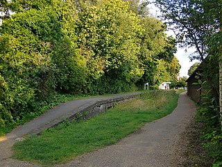
English: Site of the former Bramley & Wonersh station View SSE towards the village centre. This was once a stop on the London, Brighton & South Coast Railway's line from Guildford to Horsham. According to Dendy Marshall's 'History of the Southern Railway' (not always reliable) the line opened in October 1865. In 1923 the LBSCR became part of the newly-formed Southern Railway, which in turn became the Southern Region of British Railways in 1948. The Guildford-Horsham line closed in 1965, in the era of the 'Beeching cuts'. A contribution by Ben Brooksbank shows the station as it was a few years before closure: 1884542. The old track-bed has been re-surfaced as a cycle and pedestrian route, now included in the Downs Link. The gentle gradients of the old railway alignment make for easy cycling, and this stretch of the route is also well sheltered from wind, running within a ribbon of woodland. |
| Date | |
| Source | From geograph.org.uk |
| Author | Stefan Czapski |
| Permission (Reusing this file) |
Creative Commons Attribution Share-alike license 2.0 |
| Attribution (required by the license) | Stefan Czapski / Site of the former Bramley & Wonersh station / |
| Camera location | | View this and other nearby images on: OpenStreetMap |
|---|
.jpg¶ms=051.197024_N_-000.556892_E_globe:Earth_type:camera_source:geograph-osgb36(TQ00934519)_heading:157.00&language=en)
| Object location | | View this and other nearby images on: OpenStreetMap |
|---|
.jpg¶ms=051.196210_N_-000.556200_E_globe:Earth_class:object_type:object_source:geograph-osgb36(TQ00984510)_heading:157.00&language=en)
Licensing
[edit].jpg&action=edit§ion=2)

|
This image was taken from the Geograph project collection. See this photograph's page on the Geograph website for the photographer's contact details. The copyright on this image is owned by Stefan Czapski and is licensed for reuse under the Creative Commons Attribution-ShareAlike 2.0 license.
|
This file is licensed under the Creative Commons Attribution-Share Alike 2.0 Generic license.
Attribution: Stefan Czapski
- You are free:
- to share – to copy, distribute and transmit the work
- to remix – to adapt the work
- Under the following conditions:
- attribution – You must give appropriate credit, provide a link to the license, and indicate if changes were made. You may do so in any reasonable manner, but not in any way that suggests the licensor endorses you or your use.
- share alike – If you remix, transform, or build upon the material, you must distribute your contributions under the same or compatible license as the original.
File history
Click on a date/time to view the file as it appeared at that time.
| Date/Time | Thumbnail | Dimensions | User | Comment | |
|---|---|---|---|---|---|
| current | 12:45, 4 December 2020 | | 1,024 × 768 (323 KB) | Lamberhurst (talk | contribs) | Transferred from geograph.co.uk using [https://tools.wmflabs.org/geograph2commons/ geograph2commons] |
You cannot overwrite this file.
File usage on Commons
The following page uses this file:
.jpg&oldid=549484048)