File:Situationskort-Flensborg.png

Original file (1,235 × 825 pixels, file size: 201 KB, MIME type: image/png)
Captions
Captions
Summary
[edit]
| Description |
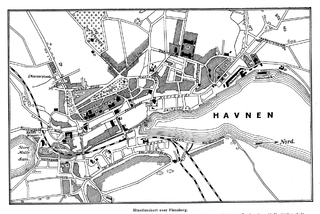
Dansk: Bykort over Flensborg by fra anden halvdel af 1800-tallet.
Forklaringer: 1. Raadhus. 2. Teater. 3. Rigsbankfilial. 4. Posthus. 5 og 6. Banegaarde. 7. Elektrisk Station. 8. Skt Hans Kirke. 9. Retsbygning. 10. Navigationsskole. 11. Gymnasium. 12. Helligaands-Klosteret. 13. Skt Nikolaj Kirke. 14. Retsbygning. 15. Vandreservoir. 16. Den ny Kirkegaard. 17. Den gamle Kirkegaard. 18. Museum. 19. Overrealskole. 20. Katolsk Kirke. 21. Dansk Kirke. 22. Dampskibspavillon. 23. Skt Marie ell. Vor Frue Kirke. 24. Skt Franciskus Hospital. 25. Diakonissestiftelse. 26. Kaserne. 27. Karantæneanstalt. 28. Gasværk. 29. Nørreport. 30. Slagteri. |
| Date | |
| Source | Salmonsens konversationsleksikon, Anden Udgave, Bind VIII: Fiévée—Friehling, København 1918, side 240 |
| Author | redigeret af Chr. Blangstrup |
Licensing
[edit]
|
This work is in the public domain in its country of origin and other countries and areas where the copyright term is the author's life plus 70 years or fewer. | |
| This file has been identified as being free of known restrictions under copyright law, including all related and neighboring rights. | |
File history
Click on a date/time to view the file as it appeared at that time.
| Date/Time | Thumbnail | Dimensions | User | Comment | |
|---|---|---|---|---|---|
| current | 15:29, 25 May 2014 | | 1,235 × 825 (201 KB) | Aspersen (talk | contribs) | User created page with UploadWizard |
You cannot overwrite this file.
File usage on Commons
There are no pages that use this file.
File usage on other wikis
The following other wikis use this file:
- Usage on da.wikipedia.org