File:Smecno1939.jpg
Jump to navigation
Jump to search

Size of this preview: 544 × 600 pixels. Other resolutions: 218 × 240 pixels | 435 × 480 pixels | 696 × 768 pixels | 928 × 1,024 pixels | 1,857 × 2,048 pixels | 3,711 × 4,093 pixels.
Original file (3,711 × 4,093 pixels, file size: 10.42 MB, MIME type: image/jpeg)
Captions
Captions
Add a one-line explanation of what this file represents
Summary[edit]
| Description |
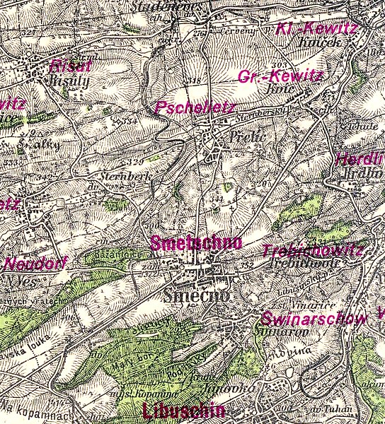
Čeština: Zaniklá železnice Slaný - Kačice na mapě vytvořené Zeměpisným ústavem Ministerstva vnitra v roce 1939. Mapa 1:75 000, výřez z mapového listu 3952
Povoleno sdílet s povinností uvedení původce: Mapová sbírka PřF UK. Allowed to share with the obligation to mention the originator: Map collection of PřF UK. |
| Date | |
| Source |
Mapová sbírka PřF UK Povoleno sdílet s povinností uvedení původce: Mapová sbírka PřF UK. Allowed to share with the obligation to mention the originator: Map collection of PřF UK. |
| Author | Zeměměřičský úřad Čechy a Morava (dříve Zeměpisný ústav ministerstva vnitra) |
Licensing[edit]
This image (or other media file) is in the public domain because its copyright has expired and its author is anonymous.
This applies to the European Union and those countries with a copyright term of 70 years after the work was made available to the public and the author never disclosed their identity. Important: Always mention where the image comes from, as far as possible, and make sure the author never claimed authorship. |
 | |
 |
Note: In Germany and possibly other countries, certain anonymous works published before July 1, 1995 are copyrighted until 70 years after the death of the author. See Übergangsrecht. Please use this template only if the author never claimed authorship or their authorship never became public in any other way. If the work is anonymous or pseudonymous (e.g., published only under a corporate or organization's name), use this template for images published more than 70 years ago.
For a work made available to the public in the United Kingdom, please use Template:PD-UK-unknown instead.
|
File history
Click on a date/time to view the file as it appeared at that time.
| Date/Time | Thumbnail | Dimensions | User | Comment | |
|---|---|---|---|---|---|
| current | 20:48, 6 May 2023 | | 3,711 × 4,093 (10.42 MB) | Pkekekrk (talk | contribs) | Uploaded a work by Povoleno sdílet s povinností uvedení původce: Mapová sbírka PřF UK. Allowed to share with the obligation to mention the originator: Map collection of PřF UK. from Mapová sbírka PřF UK with UploadWizard |
You cannot overwrite this file.
File usage on Commons
There are no pages that use this file.
File usage on other wikis
The following other wikis use this file:
- Usage on cs.wikipedia.org