File:Snow Hill, Wolverhampton - geograph.org.uk - 1763200.jpg
Jump to navigation
Jump to search

Size of this preview: 600 × 600 pixels. Other resolutions: 240 × 240 pixels | 480 × 480 pixels | 640 × 640 pixels.
Original file (640 × 640 pixels, file size: 151 KB, MIME type: image/jpeg)
Captions
Captions
Add a one-line explanation of what this file represents
Summary[edit]
| Description |
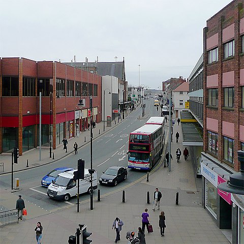
English: Snow Hill, Wolverhampton Looking south from the rooftop car park over The Wulfrun Centre. This leads towards Dudley Road (A459) and Birmingham Road (A4123).
On the left corner is the red-brick Wilkinson stores. On the right with the roof across the pavement is the former Rackham's department store, which was later occupied by Netto (surely their most squalidly managed store ever) - since also closed down. At present the premises is unoccupied. The catholic church of St Mary and St John is further up the road on the left. The 126 bus waiting at the traffic lights has come from Birmingham. I know not along which route the second bus came. |
| Date | |
| Source | From geograph.org.uk |
| Author | Roger Kidd |
| Attribution (required by the license) | Roger Kidd / Snow Hill, Wolverhampton / |
| Camera location | | View this and other nearby images on: OpenStreetMap |
|---|
_heading:180.00&language=en)
| Object location | | View this and other nearby images on: OpenStreetMap |
|---|
_heading:180.00&language=en)
Licensing[edit]

|
This image was taken from the Geograph project collection. See this photograph's page on the Geograph website for the photographer's contact details. The copyright on this image is owned by Roger Kidd and is licensed for reuse under the Creative Commons Attribution-ShareAlike 2.0 license.
|
This file is licensed under the Creative Commons Attribution-Share Alike 2.0 Generic license.
Attribution: Roger Kidd
- You are free:
- to share – to copy, distribute and transmit the work
- to remix – to adapt the work
- Under the following conditions:
- attribution – You must give appropriate credit, provide a link to the license, and indicate if changes were made. You may do so in any reasonable manner, but not in any way that suggests the licensor endorses you or your use.
- share alike – If you remix, transform, or build upon the material, you must distribute your contributions under the same or compatible license as the original.
File history
Click on a date/time to view the file as it appeared at that time.
| Date/Time | Thumbnail | Dimensions | User | Comment | |
|---|---|---|---|---|---|
| current | 21:48, 11 March 2011 | | 640 × 640 (151 KB) | GeographBot (talk | contribs) | == {{int:filedesc}} == {{Information |description={{en|1=Snow Hill, Wolverhampton Looking south from the rooftop car park over The Wulfrun Centre. This leads towards Dudley Road (A459) and Birmingham Road (A4123). On the left corner is the red-brick Wilk |
You cannot overwrite this file.
File usage on Commons
There are no pages that use this file.