File:Sobat Basin.png
Jump to navigation
Jump to search
Size of this preview: 800 × 533 pixels. Other resolutions: 320 × 213 pixels | 640 × 427 pixels | 810 × 540 pixels.
Original file (810 × 540 pixels, file size: 417 KB, MIME type: image/png)
Captions
Captions
Add a one-line explanation of what this file represents
Summary
[edit]
| Description |
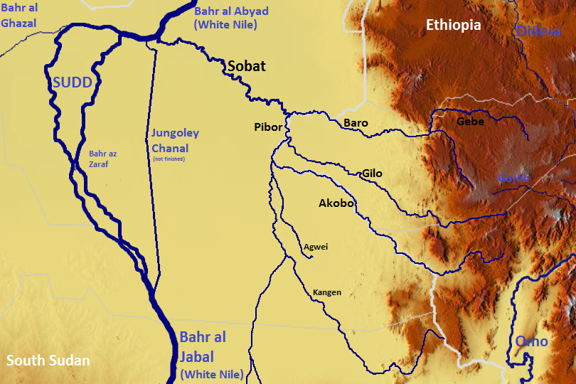
English: The Sobat, Sudd, Bahr al Gazal OSM, Based up on US Army map NC36, NB36 |
| Date | |
| Source | https://maps-for-free.com, https://maps.lib.utexas.edu/maps/imw/ |
| Author | Hans Braxmeier & Peter in s |
This file is licensed under the Creative Commons Attribution-Share Alike 2.0 Generic license.
- You are free:
- to share – to copy, distribute and transmit the work
- to remix – to adapt the work
- Under the following conditions:
- attribution – You must give appropriate credit, provide a link to the license, and indicate if changes were made. You may do so in any reasonable manner, but not in any way that suggests the licensor endorses you or your use.
- share alike – If you remix, transform, or build upon the material, you must distribute your contributions under the same or compatible license as the original.
File history
Click on a date/time to view the file as it appeared at that time.
| Date/Time | Thumbnail | Dimensions | User | Comment | |
|---|---|---|---|---|---|
| current | 23:45, 29 November 2023 | | 810 × 540 (417 KB) | Argo Navis (talk | contribs) | File:Sobat Sudd OSM.png cropped 40 % horizontally, 6 % vertically using CropTool with precise mode. |
You cannot overwrite this file.
File usage on Commons
The following page uses this file:
File usage on other wikis
The following other wikis use this file:
- Usage on hr.wikipedia.org