File:Solar heating and cooling demonstration project, which is funded by the National Science Foundation..., 05-1975. (6919970478).jpg

Original file (3,000 × 2,028 pixels, file size: 417 KB, MIME type: image/jpeg)
Captions
Captions
Summary[edit]
.jpg&action=edit§ion=1)
| Description |
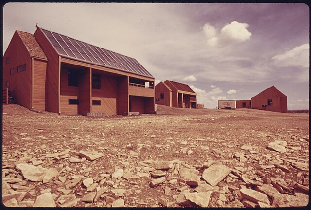
Original Caption: Solar heating and cooling demonstration project, which is funded by the National Science Foundation. This home is one of three completed by the university using a liquid solar heating system for both heating and air conditioning. At the time this picture was taken, no such systems were on the market. Flat plate collectors on the roof have blackened copper tubing to absorb heat from the sun. Heated water is piped to an 1,100 gallon tank in the basement and then is circulated through the house to heat it, 05/1975. U.S. National Archives’ Local Identifier: 412-DA-14878 Photographer: Norton, Boyd Subjects: Environmental protection Natural resources Pollution Fort Collins (Colorado, United States) inhabited place Persistent URL: research.archives.gov/description/557330 Repository: Still Picture Records Section, Special Media Archives Services Division (NWCS-S), National Archives at College Park, 8601 Adelphi Road, College Park, MD, 20740-6001. For information about ordering reproductions of photographs held by the Still Picture Unit, visit: www.archives.gov/research/order/still-pictures.html Reproductions may be ordered via an independent vendor. NARA maintains a list of vendors at www.archives.gov/research/order/vendors-photos-maps-dc.html Access Restrictions: Unrestricted Use Restrictions: Unrestricted |
| Date | Taken in May 1975 |
| Source | Solar heating and cooling demonstration project, which is funded by the National Science Foundation..., 05/1975. |
| Author | The U.S. National Archives |
| Permission (Reusing this file) |
The U.S. National Archives @ Flickr Commons |
| Camera location | | View this and other nearby images on: OpenStreetMap |
|---|
.jpg¶ms=040.581501_N_-105.076263_E_globe:Earth_type:camera_source:Flickr_&language=en)
Licensing[edit]
.jpg&action=edit§ion=2)
This image was taken from Flickr's The Commons. The uploading organization may have various reasons for determining that no known copyright restrictions exist, such as:
More information can be found at https://flickr.com/commons/usage/. Please add additional copyright tags to this image if more specific information about copyright status can be determined. See Commons:Licensing for more information. |
| This image was originally posted to Flickr by The U.S. National Archives at https://flickr.com/photos/35740357@N03/6919970478. It was reviewed on 22 November 2016 by FlickreviewR and was confirmed to be licensed under the terms of the No known copyright restrictions. |
File history
Click on a date/time to view the file as it appeared at that time.
| Date/Time | Thumbnail | Dimensions | User | Comment | |
|---|---|---|---|---|---|
| current | 03:13, 22 November 2016 | | 3,000 × 2,028 (417 KB) | Victorgrigas (talk | contribs) | Transferred from Flickr via Flickr2Commons |
You cannot overwrite this file.
File usage on Commons
There are no pages that use this file.
.jpg&oldid=729523996)