File:Soo Line.png
Jump to navigation
Jump to search
Size of this preview: 800 × 577 pixels. Other resolutions: 320 × 231 pixels | 640 × 462 pixels | 1,024 × 739 pixels | 1,074 × 775 pixels.
Original file (1,074 × 775 pixels, file size: 93 KB, MIME type: image/png)
Captions
Captions
Add a one-line explanation of what this file represents
Summary
[edit]
| Description |
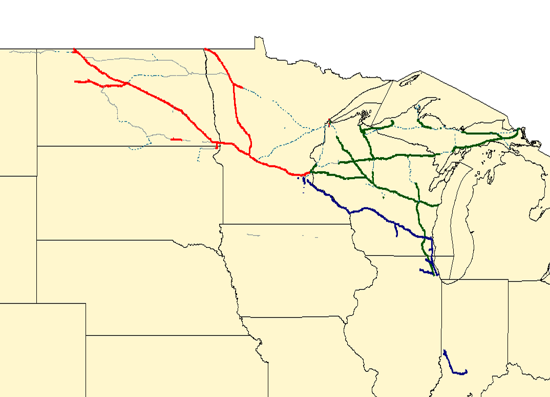
English: Map of the en:Soo Line Railroad. Red lines are former SOO trackage operated by en:CP Rail; dark blue lines are former Milwaukee Road trackage now operated by en:CP Rail; green lines are former SOO trackage spun off to the en:Wisconsin Central Railway and now part of en:Canadian National. Grey lines in North Dakota are operated by Short Lines (Dakota Missouri Valley & Western or Northern Plains Railroads). Dotted light blue lines are abandoned.
Created with Quantum GIS using data from the National Transportation Atlas. |
| Date | 3 September 2006 (original upload date) |
| Source |
Transferred from en.wikipedia to Commons. |
| Author | Original uploader was Elkman (talk) at en.wikipedia |
Licensing
[edit]
Elkman at the English language Wikipedia, the copyright holder of this work, hereby publishes it under the following licenses:

|
Permission is granted to copy, distribute and/or modify this document under the terms of the GNU Free Documentation License, Version 1.2 or any later version published by the Free Software Foundation; with no Invariant Sections, no Front-Cover Texts, and no Back-Cover Texts. A copy of the license is included in the section entitled GNU Free Documentation License. Subject to disclaimers. |
This file is licensed under the Creative Commons Attribution-Share Alike 2.5 Generic, 2.0 Generic and 1.0 Generic license.
Attribution: Elkman at the English language Wikipedia
- You are free:
- to share – to copy, distribute and transmit the work
- to remix – to adapt the work
- Under the following conditions:
- attribution – You must give appropriate credit, provide a link to the license, and indicate if changes were made. You may do so in any reasonable manner, but not in any way that suggests the licensor endorses you or your use.
- share alike – If you remix, transform, or build upon the material, you must distribute your contributions under the same or compatible license as the original.
You may select the license of your choice.
Original upload log
[edit]
The original description page was here. All following user names refer to en.wikipedia.
- 2006-09-03 17:55 Elkman 1074×775× (95338 bytes) Map of the [[Soo Line Railroad]]. Red lines are former SOO trackage operated by [[CP Rail]]; dark blue lines are former Milwaukee Road trackage now operated by [[CP Rail]]; green lines are former SOO trackage spun off to the [[Wisconsin Central Railway]]
File history
Click on a date/time to view the file as it appeared at that time.
| Date/Time | Thumbnail | Dimensions | User | Comment | |
|---|---|---|---|---|---|
| current | 11:47, 14 March 2009 | | 1,074 × 775 (93 KB) | 手練~commonswiki (talk | contribs) | {{Information |Description={{en|Map of the en:Soo Line Railroad. Red lines are former SOO trackage operated by en:CP Rail; dark blue lines are former Milwaukee Road trackage now operated by en:CP Rail; green lines are former SOO trackage s |
You cannot overwrite this file.
File usage on Commons
There are no pages that use this file.
File usage on other wikis
The following other wikis use this file:
- Usage on en.wikipedia.org
- Usage on fr.wikipedia.org
- Usage on it.wikipedia.org
- Usage on ja.wikipedia.org
- Usage on nl.wikipedia.org