File:South Dakota general map 1.png
Jump to navigation
Jump to search
No higher resolution available.
South_Dakota_general_map_1.png (763 × 530 pixels, file size: 687 KB, MIME type: image/png)
Captions
Captions
Add a one-line explanation of what this file represents
Summary[edit]
| Description |
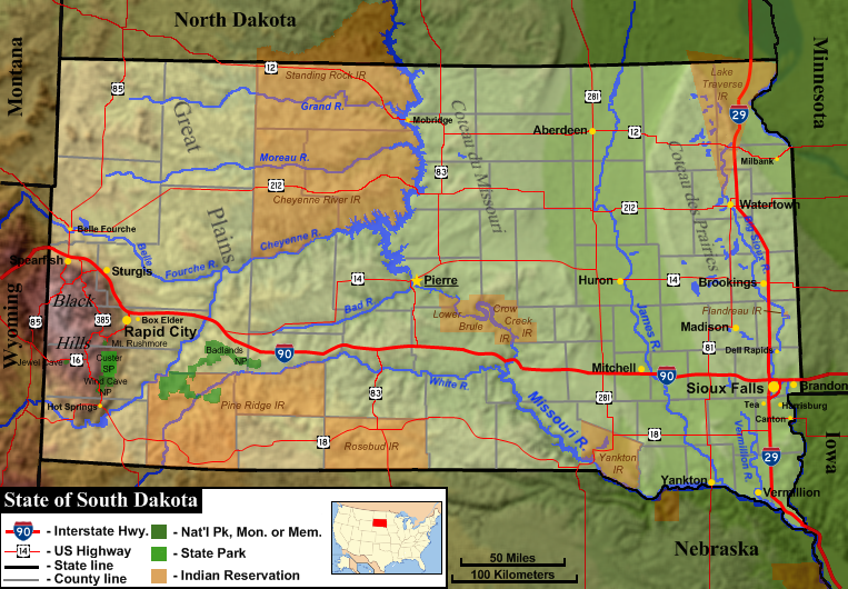
English: General map of the US state of South Dakota, showing both state and county boundaries, topography, major cities, major roads, national parks and Indian reservations. |
| Date | |
| Source | Base topography map is from the public domain National Atlas, as were several layers used as reference points. Highway shields were by User:SPUI and released to the public domain. US locator map was by User:Huebi. All other work was done by the uploader. |
| Author | Jon Platek. |
Licensing[edit]
I, the copyright holder of this work, hereby publish it under the following licenses:
This file is licensed under the Creative Commons Attribution-Share Alike 3.0 Unported license.
- You are free:
- to share – to copy, distribute and transmit the work
- to remix – to adapt the work
- Under the following conditions:
- attribution – You must give appropriate credit, provide a link to the license, and indicate if changes were made. You may do so in any reasonable manner, but not in any way that suggests the licensor endorses you or your use.
- share alike – If you remix, transform, or build upon the material, you must distribute your contributions under the same or compatible license as the original.

|
Permission is granted to copy, distribute and/or modify this document under the terms of the GNU Free Documentation License, Version 1.2 or any later version published by the Free Software Foundation; with no Invariant Sections, no Front-Cover Texts, and no Back-Cover Texts. A copy of the license is included in the section entitled GNU Free Documentation License. |
You may select the license of your choice.
File history
Click on a date/time to view the file as it appeared at that time.
| Date/Time | Thumbnail | Dimensions | User | Comment | |
|---|---|---|---|---|---|
| current | 18:51, 23 February 2010 | | 763 × 530 (687 KB) | AlexiusHoratius~commonswiki (talk | contribs) | Corrected name of Lake Traverse Indian Reservation |
| 17:13, 22 February 2010 |  | 763 × 530 (688 KB) | AlexiusHoratius~commonswiki (talk | contribs) | {{Information |Description={{en|1=Genenral map of the US state of South Dakota, showing both state and county boundaries, topography, major cities, major roads, national parks and Indian reservations.}} |Source=Base topography map is from the public domai |
You cannot overwrite this file.
File usage on Commons
There are no pages that use this file.
File usage on other wikis
The following other wikis use this file:
- Usage on en.wikipedia.org