File:Spanish territories by 1892.jpg
Jump to navigation
Jump to search
No higher resolution available.
Spanish_territories_by_1892.jpg (373 × 322 pixels, file size: 61 KB, MIME type: image/jpeg)
Captions
Captions
Add a one-line explanation of what this file represents
| Description |
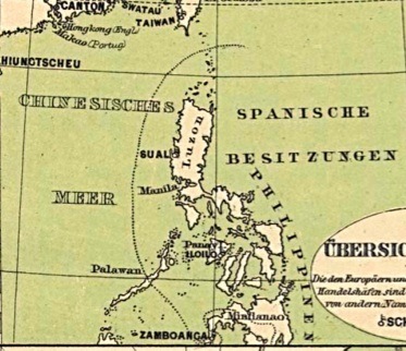
English: German map indicating the demarcation of Spanish-controlled territories vis-a-vis Moro dominated areas in the Philippine Islands, 1892 |
||
| Date | 10/30/08 | ||
| Source | Own work | ||
| Author | Jjarivera | ||
| Permission (Reusing this file) |
|
File history
Click on a date/time to view the file as it appeared at that time.
| Date/Time | Thumbnail | Dimensions | User | Comment | |
|---|---|---|---|---|---|
| current | 11:12, 29 October 2008 | | 373 × 322 (61 KB) | Jjarivera~commonswiki (talk | contribs) | {{Information |Description={{en|1=German map indicating the demarcation of Spanish-controlled territories vis-a-vis Moro dominated areas in the Philippine Islands, 1892}} |Source=Own work by uploader |Author=Jjarivera |Date=10/30/08 |Pe |
You cannot overwrite this file.
File usage on Commons
There are no pages that use this file.
File usage on other wikis
The following other wikis use this file:
- Usage on en.wikipedia.org
- Usage on zh.wikipedia.org