File:Sprachsituationnordniederlande.png
Jump to navigation
Jump to search
Size of this preview: 692 × 599 pixels. Other resolutions: 277 × 240 pixels | 554 × 480 pixels | 887 × 768 pixels | 1,136 × 984 pixels.
Original file (1,136 × 984 pixels, file size: 153 KB, MIME type: image/png)
Captions
Captions
Add a one-line explanation of what this file represents

|
This linguistic map image could be re-created using vector graphics as an SVG file. This has several advantages; see Commons:Media for cleanup for more information. If an SVG form of this image is available, please upload it and afterwards replace this template with
{{vector version available|new image name}}.
It is recommended to name the SVG file “Sprachsituationnordniederlande.svg”—then the template Vector version available (or Vva) does not need the new image name parameter. |
Summary
[edit]
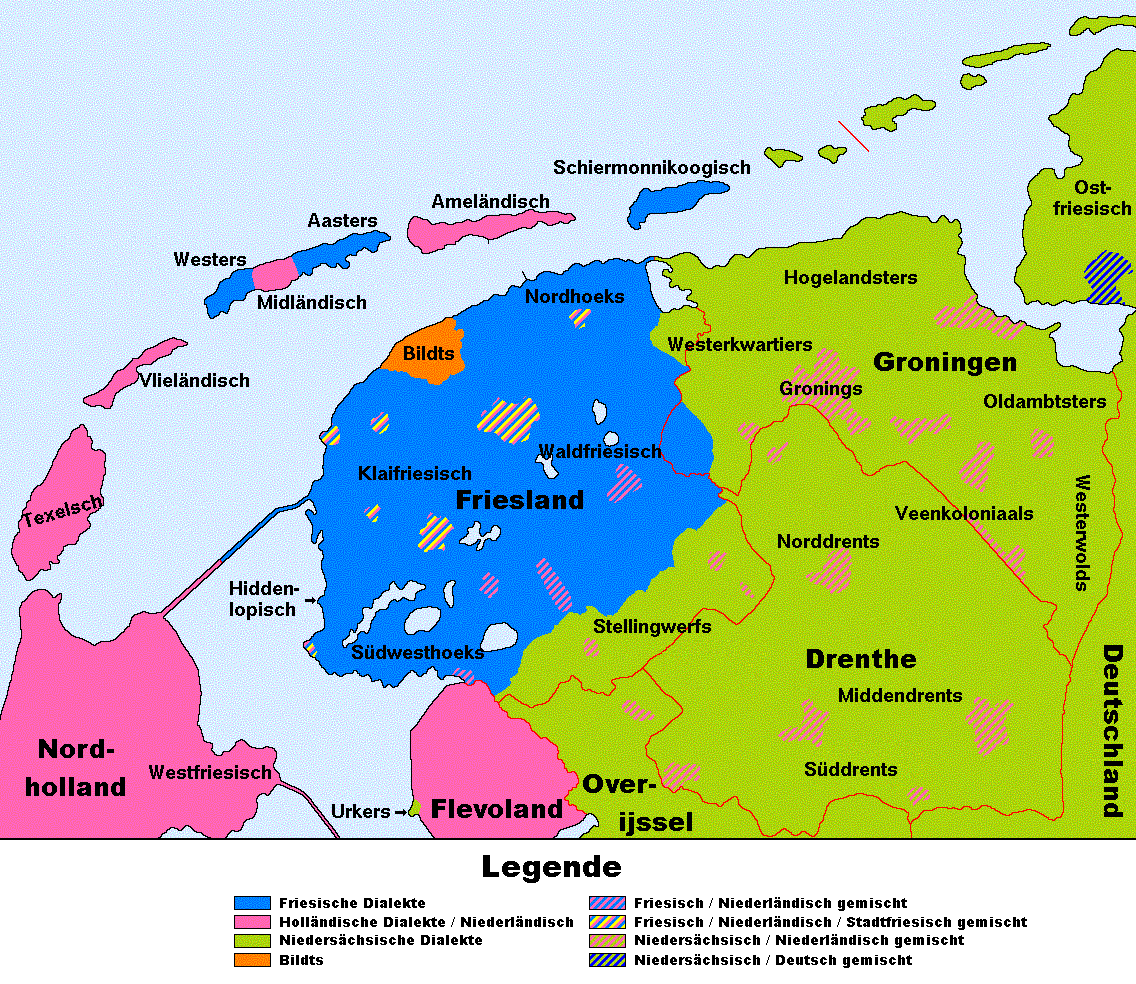
| Description | Traditionelle Sprachsituation in den nördlichen Niederlanden (Provinzen Friesland, Groningen, Drenthe und angrenzende Gebiete) |
| Date | |
| Source | Übersetzung dieser Karte |
| Author | T. Bosse, nach Vorlage von Woadan |
| Other versions | Siehe auch Version auf Niederländisch |
Licensing
[edit]

|
Permission is granted to copy, distribute and/or modify this document under the terms of the GNU Free Documentation License, Version 1.2 or any later version published by the Free Software Foundation; with no Invariant Sections, no Front-Cover Texts, and no Back-Cover Texts. A copy of the license is included in the section entitled GNU Free Documentation License. |
| This file is licensed under the Creative Commons Attribution-Share Alike 3.0 Unported license. | ||
| ||
| This licensing tag was added to this file as part of the GFDL licensing update. |
File history
Click on a date/time to view the file as it appeared at that time.
| Date/Time | Thumbnail | Dimensions | User | Comment | |
|---|---|---|---|---|---|
| current | 22:28, 14 February 2007 | | 1,136 × 984 (153 KB) | Termo (talk | contribs) | {{Information |Description=Sprachsituation in den nördlichen Niederlanden (Provinzen Friesland, Groningen, Drenthe und umliegende Gebiete). |Source=Übersetzung [http://fy.wikipedia.org/wiki/Ofbyld:L%C3%A2nkaart_taalsitewaasje_noard-nederl%C3%A2n.GIF die |
| 21:48, 14 February 2007 |  | 1,136 × 984 (153 KB) | Termo (talk | contribs) | {{Information |Description=Sprachsituation in den nördlichen Niederlanden |Source=Übersetzung [http://fy.wikipedia.org/wiki/Ofbyld:L%C3%A2nkaart_taalsitewaasje_noard-nederl%C3%A2n.GIF dieser Karte] |Date=Februar 2007 |Author=T. Bosse, nach Vorlage von |
You cannot overwrite this file.
File usage on Commons
There are no pages that use this file.
File usage on other wikis
The following other wikis use this file:
- Usage on ar.wikipedia.org
- Usage on de.wikipedia.org
- Usage on el.wikipedia.org
- Usage on en.wikipedia.org
- Usage on fr.wikipedia.org
- Usage on gv.wikipedia.org
- Usage on it.wikipedia.org
- Usage on ksh.wikipedia.org
- Usage on lv.wikipedia.org
- Usage on sat.wikipedia.org
- Usage on sl.wikipedia.org
- Usage on sq.wikipedia.org
- Usage on th.wikipedia.org