File:Spree & Kanäle.png
Jump to navigation
Jump to search

Size of this preview: 374 × 599 pixels. Other resolutions: 150 × 240 pixels | 299 × 480 pixels | 479 × 768 pixels | 639 × 1,024 pixels | 1,540 × 2,467 pixels.
Original file (1,540 × 2,467 pixels, file size: 3.98 MB, MIME type: image/png)
Captions
Captions
Add a one-line explanation of what this file represents
Summary[edit]
→ View this map in 50 % projection (770 x 1233 px)
| Description |
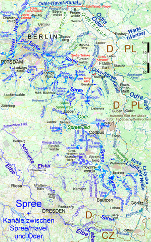
Deutsch: Karte der Spree mit ihren natürlichen und künstlichen Zuflüssen und Verzweigungen, dazu die Kanalverbindungen zwischen dem Flusssystem Spree-Havel und der Oder English: Map of Spree River with its natural and artificial affluents and branches. in addition the canals joining the Spree & Havel river system to Oder River |
| Date | |
| Source | Own work, using [1] |
| Author | Ulamm (talk) |
Licensing[edit]
I, the copyright holder of this work, hereby publish it under the following licenses:

|
Permission is granted to copy, distribute and/or modify this document under the terms of the GNU Free Documentation License, Version 1.2 or any later version published by the Free Software Foundation; with no Invariant Sections, no Front-Cover Texts, and no Back-Cover Texts. A copy of the license is included in the section entitled GNU Free Documentation License. |
This file is licensed under the Creative Commons Attribution-Share Alike 4.0 International, 3.0 Unported, 2.5 Generic, 2.0 Generic and 1.0 Generic license.
- You are free:
- to share – to copy, distribute and transmit the work
- to remix – to adapt the work
- Under the following conditions:
- attribution – You must give appropriate credit, provide a link to the license, and indicate if changes were made. You may do so in any reasonable manner, but not in any way that suggests the licensor endorses you or your use.
- share alike – If you remix, transform, or build upon the material, you must distribute your contributions under the same or compatible license as the original.
You may select the license of your choice.
File history
Click on a date/time to view the file as it appeared at that time.
| Date/Time | Thumbnail | Dimensions | User | Comment | |
|---|---|---|---|---|---|
| current | 13:37, 21 May 2016 | | 1,540 × 2,467 (3.98 MB) | Ulamm (talk | contribs) | upper course of Koselmühlenfließ |
| 11:45, 21 May 2016 |  | 1,540 × 2,467 (3.98 MB) | Ulamm (talk | contribs) | + Priorgraben u. and. Gewässer, + Weißwasser | |
| 10:13, 24 April 2016 |  | 1,540 × 2,467 (3.99 MB) | Ulamm (talk | contribs) | lock names smaller; some more names of places and flows | |
| 19:31, 18 April 2016 |  | 1,540 × 2,467 (3.99 MB) | Ulamm (talk | contribs) | two locks corrected | |
| 22:19, 7 April 2016 |  | 1,540 × 2,467 (3.99 MB) | Ulamm (talk | contribs) | some more courses of water, two more placenames | |
| 21:54, 4 April 2016 |  | 1,540 × 2,467 (4 MB) | Ulamm (talk | contribs) | Stöbber with "ö" and some minor drawings | |
| 10:00, 1 April 2016 |  | 1,540 × 2,467 (4 MB) | Ulamm (talk | contribs) | wrong "correction" reverted: GAMengrund was o.k. | |
| 09:18, 1 April 2016 |  | 1,540 × 2,467 (4 MB) | Ulamm (talk | contribs) | GaRmengrund | |
| 23:42, 29 March 2016 |  | 1,540 × 2,467 (4 MB) | Ulamm (talk | contribs) | Oder-HAVEL-Kanal ;-) | |
| 01:44, 29 March 2016 |  | 1,540 × 2,467 (3.99 MB) | Ulamm (talk | contribs) | + Ludwigsfelde and one group of river courses a bit lighter |
You cannot overwrite this file.
File usage on Commons
The following 16 pages use this file:
- Spree
- User:Chumwa/OgreBot/Potential transport maps/2016 April 1-10
- User:Chumwa/OgreBot/Potential transport maps/2016 April 11-20
- User:Chumwa/OgreBot/Potential transport maps/2016 April 21-30
- User:Chumwa/OgreBot/Potential transport maps/2016 March 21-31
- User:Chumwa/OgreBot/Potential transport maps/2016 May 21-31
- User:Chumwa/OgreBot/Transport Maps/2016 April 1-10
- User:Chumwa/OgreBot/Transport Maps/2016 April 11-20
- User:Chumwa/OgreBot/Transport Maps/2016 April 21-30
- User:Chumwa/OgreBot/Transport Maps/2016 March 21-31
- User:Chumwa/OgreBot/Transport Maps/2016 May 21-31
- User:Chumwa/OgreBot/Travel and communication maps/2016 April 1-10
- User:Chumwa/OgreBot/Travel and communication maps/2016 April 11-20
- User:Chumwa/OgreBot/Travel and communication maps/2016 April 21-30
- User:Chumwa/OgreBot/Travel and communication maps/2016 March 21-31
- User:Chumwa/OgreBot/Travel and communication maps/2016 May 21-31
File usage on other wikis
The following other wikis use this file:
- Usage on azb.wikipedia.org
- Usage on de.wikipedia.org
- Usage on dsb.wikipedia.org
- Usage on fi.wikipedia.org
- Usage on hsb.wikipedia.org
- Usage on nl.wikipedia.org
- Usage on no.wikipedia.org
- Usage on ro.wikipedia.org
- Usage on ru.wikipedia.org
- Usage on tg.wikipedia.org