File:St George's Church - geograph.org.uk - 668600.jpg
From Wikimedia Commons, the free media repository
Jump to navigation
Jump to search
St_George's_Church_-_geograph.org.uk_-_668600.jpg (640 × 480 pixels, file size: 132 KB, MIME type: image/jpeg)
File information
Structured data
Captions
Captions
Add a one-line explanation of what this file represents
Summary[edit]
| DescriptionSt George's Church - geograph.org.uk - 668600.jpg |
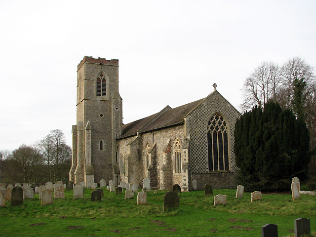
English: St George's Church. St George's church > 668599 is located about 2 kilometres northwest of Hardingham, a village consisting of scattered hamlets and groups of houses. Like a number of other churches in this area, St George has its tower not at the west end but at the south wall (seen here). The interior was extensively restored during Victorian times > 846796 - 846827 - a piscina, the George III royal arms and a C13 font > 846833 - albeit broken - have survived. A few interesting C17 ledger stones > 846822 - 846825 can be found on the chancel floor; the west end of the nave has been devoted to villagers lost during WW1. The stained glass windows date from the 19th and early 20th centuries > 846810. A window in the west wall commemorates Major William Mordaunt Marsh Edwards VC who won the Victoria Cross at Tel-el-Kebir during the Egyptian war of 1882 > 846838. A memorial window to William Bartle Marsh Edwards of the Rifle Brigade, killed in action in Tunisia, 1943, is in the north wall > 846817. The church is kept locked but a key is available at the adjoining Old Rectory > 668609. For more information see: http://www.norfolkchurches.co.uk/hardingham/hardingham.htm |
| Date | |
| Source | From geograph.org.uk |
| Author | Evelyn Simak |
| Attribution (required by the license) InfoField | Evelyn Simak / St George's Church / |
InfoField | Evelyn Simak / St George's Church |
| Camera location | 52° 36′ 21″ N, 1° 00′ 23″ E | View this and other nearby images on: OpenStreetMap |
|---|
| Object location | 52° 36′ 22″ N, 1° 00′ 17″ E | View this and other nearby images on: OpenStreetMap |
|---|
Licensing[edit]

|
This image was taken from the Geograph project collection. See this photograph's page on the Geograph website for the photographer's contact details. The copyright on this image is owned by Evelyn Simak and is licensed for reuse under the Creative Commons Attribution-ShareAlike 2.0 license.
|
This file is licensed under the Creative Commons Attribution-Share Alike 2.0 Generic license.
Attribution: Evelyn Simak
- You are free:
- to share – to copy, distribute and transmit the work
- to remix – to adapt the work
- Under the following conditions:
- attribution – You must give appropriate credit, provide a link to the license, and indicate if changes were made. You may do so in any reasonable manner, but not in any way that suggests the licensor endorses you or your use.
- share alike – If you remix, transform, or build upon the material, you must distribute your contributions under the same or compatible license as the original.
File history
Click on a date/time to view the file as it appeared at that time.
| Date/Time | Thumbnail | Dimensions | User | Comment | |
|---|---|---|---|---|---|
| current | 19:44, 7 February 2011 |  | 640 × 480 (132 KB) | GeographBot (talk | contribs) | == {{int:filedesc}} == {{Information |description={{en|1=St George's Church St George's church > http://www.geograph.org.uk/photo/668599 is located about 2 kilometres northwest of Hardingham, a village consisting of scattered hamlets and groups of houses. |
You cannot overwrite this file.
File usage on Commons
There are no pages that use this file.
Metadata
This file contains additional information such as Exif metadata which may have been added by the digital camera, scanner, or software program used to create or digitize it. If the file has been modified from its original state, some details such as the timestamp may not fully reflect those of the original file. The timestamp is only as accurate as the clock in the camera, and it may be completely wrong.
| Camera manufacturer | Canon |
|---|---|
| Camera model | Canon PowerShot S3 IS |
| Exposure time | 1/320 sec (0.003125) |
| F-number | f/4 |
| Date and time of data generation | 12:11, 26 January 2008 |
| Lens focal length | 6 mm |
| Orientation | Normal |
| Horizontal resolution | 180 dpi |
| Vertical resolution | 180 dpi |
| File change date and time | 21:37, 26 January 2008 |
| Y and C positioning | Centered |
| Software used | Adobe Photoshop CS Windows |
| Exif version | 2.2 |
| Date and time of digitizing | 12:11, 26 January 2008 |
| Image compression mode | 3 |
| APEX shutter speed | 8.3125 |
| APEX aperture | 4 |
| APEX exposure bias | 0 |
| Maximum land aperture | 2.875 APEX (f/2.71) |
| Metering mode | Pattern |
| Flash | Flash did not fire, compulsory flash suppression, red-eye reduction mode |
| Color space | sRGB |
| Focal plane X resolution | 2,844.4444444444 |
| Focal plane Y resolution | 2,840.2366863905 |
| Focal plane resolution unit | inches |
| Sensing method | One-chip color area sensor |
| Custom image processing | Normal process |
| Exposure mode | Auto exposure |
| White balance | Auto white balance |
| Digital zoom ratio | 1 |
| Scene capture type | Landscape |
