File:St Mark's, a catlover's church - geograph.org.uk - 617556.jpg
St_Mark's,_a_catlover's_church_-_geograph.org.uk_-_617556.jpg (640 × 480 pixels, file size: 74 KB, MIME type: image/jpeg)
Captions
Captions
Summary
[edit]
| Description |
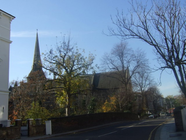
English: St Mark's, a catlover's church, near to Camden Town, Camden, Great Britain.
A Victorian Gothic church built around 1850 to cater for the expansion in the population of the St Pancras district, it was high Anglican and known as the Zoo church owing to its proximity to Regent's Park. During WW2 it received a direct hit from a German bomb and was all but destroyed. Although it was the first London church to be rebuilt after the war, it took 17 years and was largely due to the efforts of the then incumbent the Rev. Hugh Stuckey, a catlover whose cats were immortalised in the new stained glass windows. |
| Date | |
| Source | From geograph.org.uk; transferred by User:Kurpfalzbilder.de using geograph_org2commons. |
| Author | ceridwen |
| Permission (Reusing this file) |
Creative Commons Attribution Share-alike license 2.0 |
| Attribution (required by the license) | ceridwen / St Mark's, a catlover's church / |
| Camera location | | View this and other nearby images on: OpenStreetMap |
|---|
| Object location | | View this and other nearby images on: OpenStreetMap |
|---|
_region:GB-ENG_heading:225.00&language=en)
Licensing
[edit]

|
This image was taken from the Geograph project collection. See this photograph's page on the Geograph website for the photographer's contact details. The copyright on this image is owned by ceridwen and is licensed for reuse under the Creative Commons Attribution-ShareAlike 2.0 license.
|
- You are free:
- to share – to copy, distribute and transmit the work
- to remix – to adapt the work
- Under the following conditions:
- attribution – You must give appropriate credit, provide a link to the license, and indicate if changes were made. You may do so in any reasonable manner, but not in any way that suggests the licensor endorses you or your use.
- share alike – If you remix, transform, or build upon the material, you must distribute your contributions under the same or compatible license as the original.
File history
Click on a date/time to view the file as it appeared at that time.
| Date/Time | Thumbnail | Dimensions | User | Comment | |
|---|---|---|---|---|---|
| current | 21:24, 9 September 2010 | | 640 × 480 (74 KB) | File Upload Bot (Magnus Manske) (talk | contribs) | == {{int:filedesc}} == {{Information |Description={{en|1=St Mark's, a catlover's church, near to Camden Town, Camden, Great Britain. A Victorian Gothic church built around 1850 to cater for the expansion in the population of the St Pancras dist |
You cannot overwrite this file.
File usage on Commons
There are no pages that use this file.