File:St Mary's church - C14 grisaille glass - geograph.org.uk - 1384536.jpg
Jump to navigation
Jump to search
Size of this preview: 310 × 599 pixels. Other resolutions: 124 × 240 pixels | 331 × 640 pixels.
Original file (331 × 640 pixels, file size: 99 KB, MIME type: image/jpeg)
Captions
Captions
Add a one-line explanation of what this file represents
Summary[edit]
| Description |
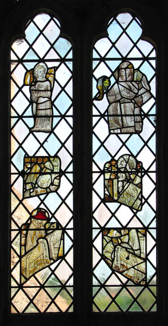
English: St Mary's church - C14 grisaille glass. See > 1384539 for detail.
St Mary's > https://www.geograph.org.uk/photo/1384466 - https://www.geograph.org.uk/photo/1384482 is located on an elevation above the village of Saxlingham Nethergate > https://www.geograph.org.uk/photo/1384404 adjoining the Old Hall on one side and the Old Rectory on the other. Unusually, the C14 square tower has a clock with a sun dial underneath it. The church was extensively restored > https://www.geograph.org.uk/photo/1384485 in the late 19th century, when the large north aisle was added. The south door > https://www.geograph.org.uk/photo/1384477 dates from medieval times and is pierced by two decorative iron grilles which have wooden cover-hatches. The nave roof including the corbels is original C15 and the octagonal font > https://www.geograph.org.uk/photo/1384572 dates from the same time. The most historically interesting feature of St Mary's is the stained glass > https://www.geograph.org.uk/photo/1384492 - https://www.geograph.org.uk/photo/1384527 some of which medieval and made by stained glass artists of the Norwich School. Several windows contain 14th century grisaille (monochrome) glass with silver stain > https://www.geograph.org.uk/photo/1384496 - which produces the bright yellow colour. The four roundels > https://www.geograph.org.uk/photo/1384558 set into one of the chancel south windows are believed to be the earliest figurative glass in Norfolk, made not later than 1250. Some of the old glass of the church is believed to have come from neighbouring St Mary's at the former hamlet of Saxlingham Thorpe - a public footpath leads past the ruin > https://www.geograph.org.uk/photo/1384209 located beside Plummer's Lane, further to the south. St Mary's church is open every day. |
| Date | |
| Source | From geograph.org.uk |
| Author | Evelyn Simak |
| Attribution (required by the license) | Evelyn Simak / St Mary's church - C14 grisaille glass / |
_-_geograph.org.uk_-_1384539.jpg)
| Camera location | | View this and other nearby images on: OpenStreetMap |
|---|
_heading:0.00&language=en)
| Object location | | View this and other nearby images on: OpenStreetMap |
|---|
_heading:0.00&language=en)
Licensing[edit]

|
This image was taken from the Geograph project collection. See this photograph's page on the Geograph website for the photographer's contact details. The copyright on this image is owned by Evelyn Simak and is licensed for reuse under the Creative Commons Attribution-ShareAlike 2.0 license.
|
This file is licensed under the Creative Commons Attribution-Share Alike 2.0 Generic license.
Attribution: Evelyn Simak
- You are free:
- to share – to copy, distribute and transmit the work
- to remix – to adapt the work
- Under the following conditions:
- attribution – You must give appropriate credit, provide a link to the license, and indicate if changes were made. You may do so in any reasonable manner, but not in any way that suggests the licensor endorses you or your use.
- share alike – If you remix, transform, or build upon the material, you must distribute your contributions under the same or compatible license as the original.
File history
Click on a date/time to view the file as it appeared at that time.
| Date/Time | Thumbnail | Dimensions | User | Comment | |
|---|---|---|---|---|---|
| current | 19:42, 28 February 2011 | | 331 × 640 (99 KB) | GeographBot (talk | contribs) | == {{int:filedesc}} == {{Information |description={{en|1=St Mary's church - C14 grisaille glass See > http://www.geograph.org.uk/photo/1384539 for detail. St Mary's > http://www.geograph.org.uk/photo/1384466 - http://www.geograph.org.uk/photo/1384482 i |
You cannot overwrite this file.
File usage on Commons
There are no pages that use this file.