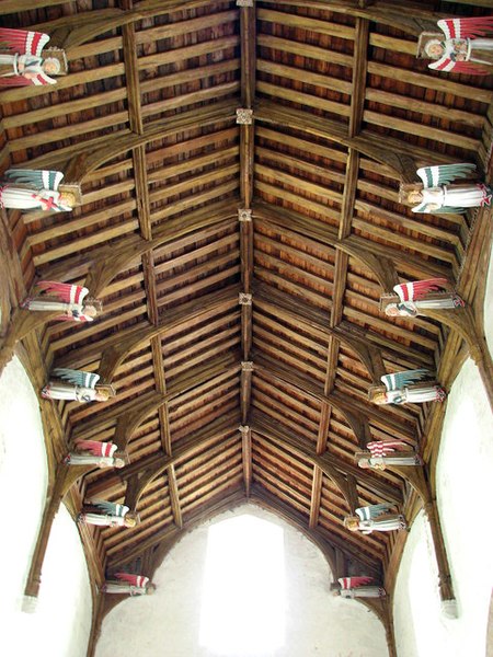
File:St Mary's church - angel roof - geograph.org.uk - 942478.jpg
From Wikimedia Commons, the free media repository
Jump to navigation
Jump to search

Size of this preview: 450 × 600 pixels. Other resolutions: 180 × 240 pixels | 480 × 640 pixels.
Original file (480 × 640 pixels, file size: 176 KB, MIME type: image/jpeg)
File information
Structured data
Captions
Captions
Add a one-line explanation of what this file represents
Summary[edit]
| DescriptionSt Mary's church - angel roof - geograph.org.uk - 942478.jpg |
English: St Mary's church - angel roof. The chancel > 942451 - 942459 is the oldest part of St Mary's church 942417 - 942447 - 942469 and was built in the 1200s. From 1312 onwards the church was owned by the Castleacre Priory until it was dissolved in 1540. The nave dates from the 14th century as does the squat short tower which was probably never finished. The angel roof (seen here) is C15 and was restored in 1958 and 1970. Other medieval survivals are the stained glass panels > 942472 - 942473 in the windows, rearranged in the north aisle windows by Revd Henry Goggs MA (1824-1858), who was called the hunting parson. The rood screen > 942450 is C15 also, as is the hexagonal wineglass pulpit > 942465. One of only 25 seven sacrament fonts in Norfolk, the panels of the baptismal font > 942482 are very much defaced. Some of the pews in the chancel have old bench ends with poppyheads and animal carvings > 942462. The rood - the modern crucifix with the figures of St Mary and St John - came from the redundant church of St Mary-at-the-Walls in Colchester, Suffolk; it was given in memory of Henry Grimwade > 942457 who was churchwarden of that church for 47 years. The tower screen > 942485 dates from the early 20th century. (Information taken from a leaflet compiled by Sheila Upjohn). St Mary's is open every day. See also: http://www.norfolkchurches.co.uk/southcreake/southcreake.htm |
| Date | |
| Source | From geograph.org.uk |
| Author | Evelyn Simak |
| Attribution (required by the license) InfoField | Evelyn Simak / St Mary's church - angel roof / |
InfoField | Evelyn Simak / St Mary's church - angel roof |
| Camera location | 52° 53′ 30″ N, 0° 45′ 22″ E | View this and other nearby images on: OpenStreetMap |
|---|
| Object location | 52° 53′ 30″ N, 0° 45′ 22″ E | View this and other nearby images on: OpenStreetMap |
|---|
Licensing[edit]

|
This image was taken from the Geograph project collection. See this photograph's page on the Geograph website for the photographer's contact details. The copyright on this image is owned by Evelyn Simak and is licensed for reuse under the Creative Commons Attribution-ShareAlike 2.0 license.
|
This file is licensed under the Creative Commons Attribution-Share Alike 2.0 Generic license.
Attribution: Evelyn Simak
- You are free:
- to share – to copy, distribute and transmit the work
- to remix – to adapt the work
- Under the following conditions:
- attribution – You must give appropriate credit, provide a link to the license, and indicate if changes were made. You may do so in any reasonable manner, but not in any way that suggests the licensor endorses you or your use.
- share alike – If you remix, transform, or build upon the material, you must distribute your contributions under the same or compatible license as the original.
File history
Click on a date/time to view the file as it appeared at that time.
| Date/Time | Thumbnail | Dimensions | User | Comment | |
|---|---|---|---|---|---|
| current | 11:03, 22 February 2011 |  | 480 × 640 (176 KB) | GeographBot (talk | contribs) | == {{int:filedesc}} == {{Information |description={{en|1=St Mary's church - angel roof The chancel > http://www.geograph.org.uk/photo/942451 - http://www.geograph.org.uk/photo/942459 is the oldest part of St Mary's church http://www.geograph.org.uk/photo |
You cannot overwrite this file.
File usage on Commons
There are no pages that use this file.
Metadata
This file contains additional information such as Exif metadata which may have been added by the digital camera, scanner, or software program used to create or digitize it. If the file has been modified from its original state, some details such as the timestamp may not fully reflect those of the original file. The timestamp is only as accurate as the clock in the camera, and it may be completely wrong.
| Camera manufacturer | Canon |
|---|---|
| Camera model | Canon PowerShot S3 IS |
| Exposure time | 1/4 sec (0.25) |
| F-number | f/2.7 |
| Date and time of data generation | 13:25, 29 August 2008 |
| Lens focal length | 6 mm |
| Orientation | Normal |
| Horizontal resolution | 180 dpi |
| Vertical resolution | 180 dpi |
| Software used | Adobe Photoshop CS Windows |
| File change date and time | 10:50, 30 August 2008 |
| Y and C positioning | Centered |
| Custom image processing | Normal process |
| Exposure mode | Auto exposure |
| White balance | Auto white balance |
| Digital zoom ratio | 1 |
| Scene capture type | Landscape |
| Exif version | 2.2 |
| Date and time of digitizing | 13:25, 29 August 2008 |
| Image compression mode | 3 |
| APEX shutter speed | 2 |
| APEX aperture | 2.875 |
| APEX exposure bias | 0 |
| Maximum land aperture | 2.875 APEX (f/2.71) |
| Metering mode | Pattern |
| Flash | Flash fired, auto mode, red-eye reduction mode |
| Color space | sRGB |
| Focal plane X resolution | 2,840.2366863905 |
| Focal plane Y resolution | 2,844.4444444444 |
| Focal plane resolution unit | inches |
| Sensing method | One-chip color area sensor |