File:St Peter's church - ledger slab - geograph.org.uk - 773256.jpg
Jump to navigation
Jump to search
No higher resolution available.
St_Peter's_church_-_ledger_slab_-_geograph.org.uk_-_773256.jpg (640 × 480 pixels, file size: 186 KB, MIME type: image/jpeg)
Captions
Captions
Add a one-line explanation of what this file represents
Summary[edit]
| Description |
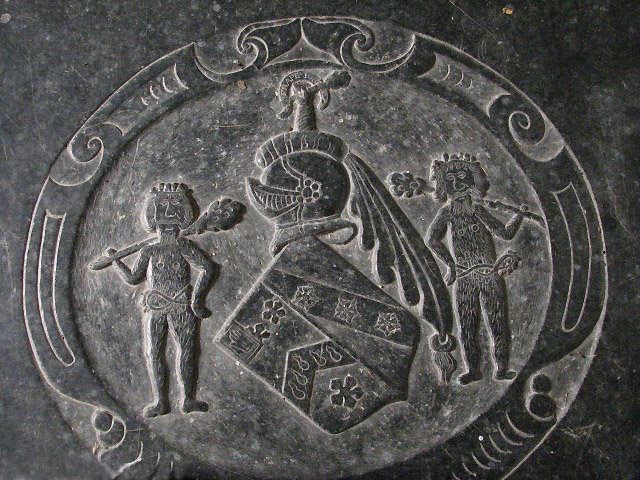
English: St Peter's Church, Kimberley, Norfolk, detail from ledger stone of Sir Thomas Wodehouse, 2nd Baronet (c.1585-1658), who built the church tower. He married Blanche Carey (d.1651), a daughter of John Carey, 3rd Baron Hunsdon. On a shield couchée supported by two "wild men" (Montague-Smith, P.W. (ed.), Debrett's Peerage, Baronetage, Knightage and Companionage, Kelly's Directories Ltd, Kingston-upon-Thames, 1968, p.639) (also known as "woodwoses"): Sable, a chevron or guttée de sang between three cinquefoils ermine (Wodehouse) with a canton of a baronet, impaling: Argent, on a bend sable three roses of the field (Cary/Carey). Crest: A dexter arm couped below the elbow vested argent and grasping a club or (Debrett's Peerage) with motto above: Frappe Fort ("strike hard").
General notesThe church was extensively restored in the 1870s > 773236; its perhaps most noteworthy features are the stained glass windows, memorials to the Wodehouses of Kimberley Hall. The east window contains fragments of English and continental glass dating from the 14th and 15th centuries > 773246 - 773248. A 1950s window in the north nave wall depicts episodes from the life of St Francis > 773251. The church is kept locked; a key is available. For more information see: http://www.norfolkchurches.co.uk/kimberley/kimberley.htm |
| Date | |
| Source | From geograph.org.uk |
| Author | Evelyn Simak |
| Attribution (required by the license) | Evelyn Simak / St Peter's church - ledger slab / |
| Camera location | | View this and other nearby images on: OpenStreetMap |
|---|
_heading:67.00&language=en)
| Object location | | View this and other nearby images on: OpenStreetMap |
|---|
_heading:67.00&language=en)
Licensing[edit]

|
This image was taken from the Geograph project collection. See this photograph's page on the Geograph website for the photographer's contact details. The copyright on this image is owned by Evelyn Simak and is licensed for reuse under the Creative Commons Attribution-ShareAlike 2.0 license.
|
This file is licensed under the Creative Commons Attribution-Share Alike 2.0 Generic license.
Attribution: Evelyn Simak
- You are free:
- to share – to copy, distribute and transmit the work
- to remix – to adapt the work
- Under the following conditions:
- attribution – You must give appropriate credit, provide a link to the license, and indicate if changes were made. You may do so in any reasonable manner, but not in any way that suggests the licensor endorses you or your use.
- share alike – If you remix, transform, or build upon the material, you must distribute your contributions under the same or compatible license as the original.
File history
Click on a date/time to view the file as it appeared at that time.
| Date/Time | Thumbnail | Dimensions | User | Comment | |
|---|---|---|---|---|---|
| current | 23:07, 19 February 2011 | | 640 × 480 (186 KB) | GeographBot (talk | contribs) | == {{int:filedesc}} == {{Information |description={{en|1=St Peter's church - ledger slab Detail of ledger slab (located on the sanctuary floor) to Sir Thomas Wodehouse (who completed the tower), with two woodwose depicted in his coat of arms. The churc |
You cannot overwrite this file.
File usage on Commons
There are no pages that use this file.
File usage on other wikis
The following other wikis use this file:
- Usage on en.wikipedia.org