File:State population per electoral vote.png
Jump to navigation
Jump to search

Size of this preview: 800 × 519 pixels. Other resolutions: 320 × 208 pixels | 640 × 415 pixels | 1,024 × 664 pixels | 1,280 × 831 pixels | 2,560 × 1,661 pixels | 3,742 × 2,428 pixels.
Original file (3,742 × 2,428 pixels, file size: 846 KB, MIME type: image/png)
Captions
Captions
Add a one-line explanation of what this file represents

|
This graph image could be re-created using vector graphics as an SVG file. This has several advantages; see Commons:Media for cleanup for more information. If an SVG form of this image is available, please upload it and afterwards replace this template with
{{vector version available|new image name}}.
It is recommended to name the SVG file “State population per electoral vote.svg”—then the template Vector version available (or Vva) does not need the new image name parameter. |
Summary[edit]
| Description |
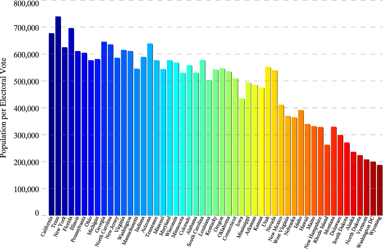
English: State population per electoral vote for the 50 states and Washington D.C. States are ranked from left to right based on total population, listed at http://en.wikipedia.org/wiki/List_of_U.S._states_and_territories_by_population#States_and_territories as of October 28, 2012. |
| Date | |
| Source | Data for the figure used state population & electoral information available on wikipedia. Figure was made using the IDL programming language. |
| Author | Fzxboy |
Licensing[edit]
I, the copyright holder of this work, hereby publish it under the following licenses:

|
Permission is granted to copy, distribute and/or modify this document under the terms of the GNU Free Documentation License, Version 1.2 or any later version published by the Free Software Foundation; with no Invariant Sections, no Front-Cover Texts, and no Back-Cover Texts. A copy of the license is included in the section entitled GNU Free Documentation License. |
This file is licensed under the Creative Commons Attribution-Share Alike 3.0 Unported license.
- You are free:
- to share – to copy, distribute and transmit the work
- to remix – to adapt the work
- Under the following conditions:
- attribution – You must give appropriate credit, provide a link to the license, and indicate if changes were made. You may do so in any reasonable manner, but not in any way that suggests the licensor endorses you or your use.
- share alike – If you remix, transform, or build upon the material, you must distribute your contributions under the same or compatible license as the original.
You may select the license of your choice.
File history
Click on a date/time to view the file as it appeared at that time.
| Date/Time | Thumbnail | Dimensions | User | Comment | |
|---|---|---|---|---|---|
| current | 13:17, 28 October 2012 | | 3,742 × 2,428 (846 KB) | Fzxboy (talk | contribs) | {{subst:Upload marker added by en.wp UW}} {{Information |Description = {{en|State population per electoral vote for the 50 states and Washington D.C. States are ranked from left to right based on total population, listed at http://en.wikipedia.org/wik... |
You cannot overwrite this file.
File usage on Commons
There are no pages that use this file.
File usage on other wikis
The following other wikis use this file:
- Usage on de.wikipedia.org
- Usage on en.wikipedia.org
- Usage on fr.wikipedia.org
- Usage on he.wikipedia.org
- Usage on ja.wikipedia.org
- Usage on nl.wikipedia.org
- Usage on si.wikipedia.org