File:Sudan positionmap with districts Nahr an-Nil.svg
Jump to navigation
Jump to search

Size of this PNG preview of this SVG file: 466 × 600 pixels. Other resolutions: 186 × 240 pixels | 373 × 480 pixels | 597 × 768 pixels | 796 × 1,024 pixels | 1,591 × 2,048 pixels | 725 × 933 pixels.
Original file (SVG file, nominally 725 × 933 pixels, file size: 155 KB)
Captions
Captions
Add a one-line explanation of what this file represents
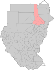
| Description | Positionmap with districts of Sudan for use in templates with Nahr an-Nil state colored | ||
| Date | |||
| Source | own work, based on Image:Sudan positionmap with districts.svg | ||
| Author | de:user:Sven-steffen arndt | ||
| Permission (Reusing this file) |
|
File history
Click on a date/time to view the file as it appeared at that time.
| Date/Time | Thumbnail | Dimensions | User | Comment | |
|---|---|---|---|---|---|
| current | 23:54, 21 January 2007 | | 725 × 933 (155 KB) | Sven-steffen arndt (talk | contribs) | {{Information |Description=Positionmap with districts of Sudan for use in templates with Nahr an-Nil state colored |Source=own work, based on Image:Sudan positionmap with districts.svg |Date=20. Janaury 2007 |Author=de:user:Sven-steffen arndt |P |
You cannot overwrite this file.
File usage on Commons
There are no pages that use this file.
File usage on other wikis
The following other wikis use this file:
- Usage on de.wiktionary.org