File:Superior amo 2009062 lrg.jpg
Jump to navigation
Jump to search

Size of this preview: 600 × 600 pixels. Other resolutions: 240 × 240 pixels | 480 × 480 pixels | 768 × 768 pixels | 1,024 × 1,024 pixels | 2,048 × 2,048 pixels | 4,552 × 4,552 pixels.
Original file (4,552 × 4,552 pixels, file size: 3.51 MB, MIME type: image/jpeg)
Captions
Captions
Add a one-line explanation of what this file represents
Summary[edit]
| Description |
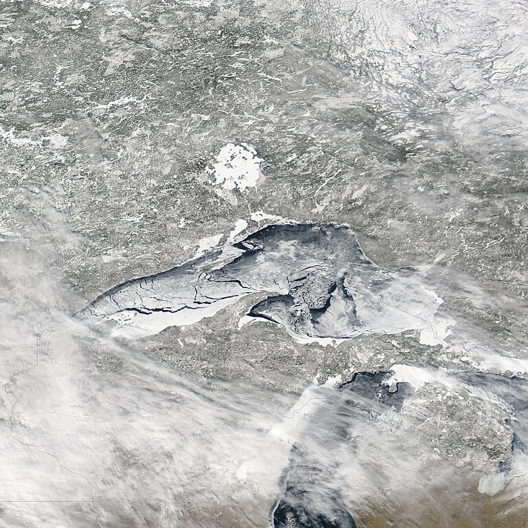
English: A relatively rare blanket of ice rested on the surface of Lake Superior in early March 2009. The Moderate Resolution Imaging Spectroradiometer (MODIS) on NASA’s Aqua satellite captured this image of the lake and its surroundings on March 3, 2009.
In this true-color, photo-like image, ice floating on the surface of Lake Superior ranges in color from white to pale gray-blue. The ice appears most solid along the southern shore of the western half of the lake. North of that solid band of ice, cracks reveal deep blue lake water. Dark lake water also appears in the eastern part of the lake, especially along its northern shore. As it does in the west, ice cover appears relatively unbroken at the extreme southeast end of the lake. |
| Date | acquired March 3, 2009 |
| Source | http://earthobservatory.nasa.gov/IOTD/view.php?id=37466 |
| Author | NASA image courtesy MODIS Rapid Response Team, Goddard Space Flight Center. Caption by Michon Scott based on image interpretation by Walt Meier, National Snow and Ice Data Center. |
Licensing[edit]
| This file is in the public domain in the United States because it was solely created by NASA. NASA copyright policy states that "NASA material is not protected by copyright unless noted". (See Template:PD-USGov, NASA copyright policy page or JPL Image Use Policy.) | ||
 |
Warnings:
|
File history
Click on a date/time to view the file as it appeared at that time.
| Date/Time | Thumbnail | Dimensions | User | Comment | |
|---|---|---|---|---|---|
| current | 15:25, 13 March 2009 | | 4,552 × 4,552 (3.51 MB) | Shizhao (talk | contribs) | {{Information |Description={{en|1=A relatively rare blanket of ice rested on the surface of Lake Superior in early March 2009. The Moderate Resolution Imaging Spectroradiometer (MODIS) on NASA’s Aqua satellite captured this image of the lake and its sur |
You cannot overwrite this file.
File usage on Commons
There are no pages that use this file.
File usage on other wikis
The following other wikis use this file:
- Usage on hy.wikipedia.org
- Usage on ru.wikipedia.org