File:Surrender Hill 02, plaque on monument.jpg
Jump to navigation
Jump to search
Size of this preview: 800 × 600 pixels. Other resolutions: 320 × 240 pixels | 640 × 480 pixels | 1,024 × 768 pixels | 1,280 × 960 pixels | 2,048 × 1,536 pixels.
Original file (2,048 × 1,536 pixels, file size: 739 KB, MIME type: image/jpeg)
Captions
Captions
Add a one-line explanation of what this file represents
Summary
[edit]
| Description |
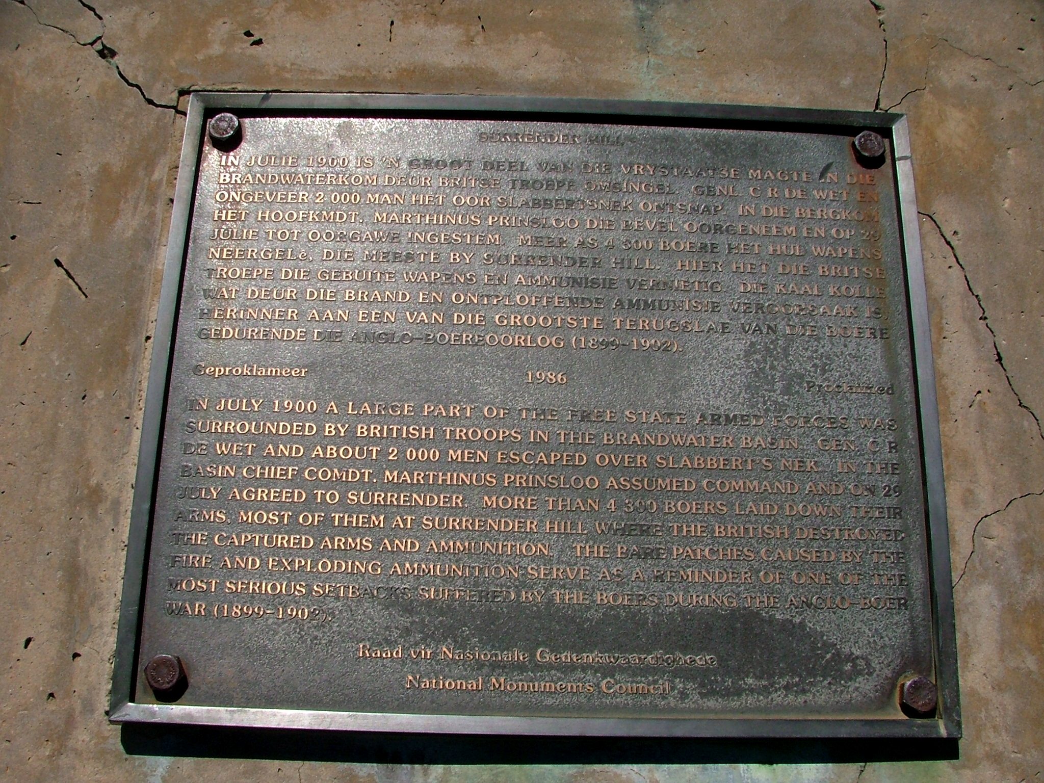
Afrikaans: Plaket met inskripsie te Surrender Hill, langs die Clarens-Fouriesburgpad in die oos-Vrystaat, Suid-Afrika. Die inskrif lui:
"In Julie 1900 is 'n groot deel van die Vrystaatse magte in die Brandwaterkom deur Britse troepe omsingel. Gen C R De Wet en ongeveer 2 000 man het oor Slabbertsnek ontsnap. In die bergkom het Hoofkomdt. Marthinus Prinsloo die bevel oorgeneem en op 29 Julie tot oorgawe ingestem. Meer as 4 300 boere het hul wapens neergelê, die meeste by Surrender Hill. Hier het die Britse troepe die gebuite wapens en ammunisie vernietig. Die kaal kolle wat deur die brand en ontploffende ammunisie veroorsaak is herinner aan een van die grootste terugslae van die boere gedurende die Anglo-Boereoorlog (1899-1902). Geproklameer 1986. Raad vir Nasionale Gedenkwaardighede." English: Plaque with inscription at Surrender Hill, beside the Clarens-Fouriesburg road in the eastern Free State, South Africa. The inscription reads: "In July 1900 a large part of the Free State armed forces was surrounded by British troops in the Brandwater Basin. Gen. C.R. De Wet and about 2 000 men escaped over Slabbert’s Nek. In the basin Chief Comdt Marthinus Prinsloo assumed command and on 29 July agreed to surrender. More than 4 300 Boers laid down their arms, most of them at Surrender Hill, where the British destroyed the captured arms and ammunition. The bare patches caused by the fire and exploding ammunition serve as a reminder of one of the most serious setbacks suffered by the Boers during the Anglo-Boer War (1899-1902). National Monuments Council." |
| Date | 1986. Photograph: 20 October 2011, 15:52 (original upload date) |
| Source | Own work by the original uploader (Original text: I (BoonDock (talk) 15:52, 20 October 2011 (UTC)) took this photo of the Plaque on the monument) |
| Author | BoonDock at English Wikipedia |
| Object location | | View this and other nearby images on: OpenStreetMap |
|---|
Licensing
[edit]
BoonDock at English Wikipedia, the copyright holder of this work, hereby publishes it under the following license:
This file is licensed under the Creative Commons Attribution 3.0 Unported license.
Attribution: BoonDock at English Wikipedia
- You are free:
- to share – to copy, distribute and transmit the work
- to remix – to adapt the work
- Under the following conditions:
- attribution – You must give appropriate credit, provide a link to the license, and indicate if changes were made. You may do so in any reasonable manner, but not in any way that suggests the licensor endorses you or your use.
Original upload log
[edit]
The original description page was here. All following user names refer to en.wikipedia.
- 2011-10-20 15:52 BoonDock 2048×1536× (829234 bytes) I (~~~~) took this photo of the Plaque on the monument
File history
Click on a date/time to view the file as it appeared at that time.
| Date/Time | Thumbnail | Dimensions | User | Comment | |
|---|---|---|---|---|---|
| current | 19:34, 13 September 2015 | | 2,048 × 1,536 (739 KB) | OgreBot (talk | contribs) | (BOT): Reverting to most recent version before archival |
| 19:34, 13 September 2015 |  | 2,048 × 1,536 (810 KB) | OgreBot (talk | contribs) | (BOT): Uploading old version of file from en.wikipedia; originally uploaded on 2011-10-20 15:52:02 by BoonDock | |
| 10:28, 7 September 2015 |  | 2,048 × 1,536 (739 KB) | JMK (talk | contribs) | {{Information |Description ={{en|1=Plaque with inscription at Surrender Hill, }} |Source ={{Own}} I (BoonDock (talk) 15:52, 20 October 2011 (UTC)) took this photo of the Plaque on the monument (first... |
You cannot overwrite this file.
File usage on Commons
There are no pages that use this file.
File usage on other wikis
The following other wikis use this file:
- Usage on en.wikipedia.org