File:SyrianDesert2.svg
Jump to navigation
Jump to search

Size of this PNG preview of this SVG file: 800 × 500 pixels. Other resolutions: 320 × 200 pixels | 640 × 400 pixels | 1,024 × 640 pixels | 1,280 × 800 pixels | 2,560 × 1,600 pixels | 1,440 × 900 pixels.
Original file (SVG file, nominally 1,440 × 900 pixels, file size: 4.8 MB)
Captions
Captions
Add a one-line explanation of what this file represents
Summary[edit]
| Description |
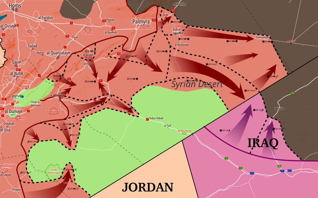
English: Situation of Southern Syria between May 8 - present. Map shows the advancements in the second Syrian Desert Offensive. Made in Inkscape and influenced by many maps from creators: PetoLucem, A7_Mirza, SouthFront, and MrPenguin20.
Controlled by the Syrian opposition
Controlled by the Ba'athist Syrian government
Controlled by the Iraqi government
Controlled by the Islamic State of Iraq and the Levant (ISIL, ISIS, IS, Daesh) |
| Date | |
| Source | Own work |
| Author | Rr016 |
Licensing[edit]
I, the copyright holder of this work, hereby publish it under the following license:
This file is licensed under the Creative Commons Attribution-Share Alike 4.0 International license.
- You are free:
- to share – to copy, distribute and transmit the work
- to remix – to adapt the work
- Under the following conditions:
- attribution – You must give appropriate credit, provide a link to the license, and indicate if changes were made. You may do so in any reasonable manner, but not in any way that suggests the licensor endorses you or your use.
- share alike – If you remix, transform, or build upon the material, you must distribute your contributions under the same or compatible license as the original.
File history
Click on a date/time to view the file as it appeared at that time.
| Date/Time | Thumbnail | Dimensions | User | Comment | |
|---|---|---|---|---|---|
| current | 16:25, 11 July 2017 | | 1,440 × 900 (4.8 MB) | Rr016 (talk | contribs) | Update. Major SAA attack west of al Tanf. |
| 18:05, 26 June 2017 |  | 1,440 × 900 (4.79 MB) | Rr016 (talk | contribs) | Update, SAA advancing towards T2 station, captures large area of desert. | |
| 17:28, 23 June 2017 |  | 1,440 × 900 (4.78 MB) | Rr016 (talk | contribs) | Updates, Iraqi PMU forces linked up with SAA on border, SAA takes control of Tal Ghurab north of al Tanf (6/22) and al Waer dam southwest of T2 pumping station (6/23). | |
| 17:01, 15 June 2017 |  | 1,440 × 900 (4.78 MB) | Rr016 (talk | contribs) | Small update, SAA captured Arak and T3 pumping station. | |
| 18:01, 13 June 2017 |  | 1,440 × 900 (4.78 MB) | Rr016 (talk | contribs) | User created page with UploadWizard |
You cannot overwrite this file.
File usage on Commons
The following 3 pages use this file:
File usage on other wikis
The following other wikis use this file:
- Usage on ar.wikipedia.org
- Usage on be.wikipedia.org
- Usage on en.wikipedia.org
- Usage on es.wikipedia.org
- Usage on fa.wikipedia.org
- Usage on fr.wikipedia.org
- Usage on ko.wikipedia.org
- Usage on pt.wikipedia.org
- Usage on ru.wikipedia.org
- Usage on www.wikidata.org
- Usage on zh.wikipedia.org