File:TER Elsass.svg
Jump to navigation
Jump to search

Size of this PNG preview of this SVG file: 314 × 392 pixels. Other resolutions: 192 × 240 pixels | 384 × 480 pixels | 615 × 768 pixels | 820 × 1,024 pixels | 1,640 × 2,048 pixels.
Original file (SVG file, nominally 314 × 392 pixels, file size: 68 KB)
Captions
Captions
Add a one-line explanation of what this file represents
Summary[edit]
| Description |
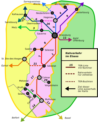
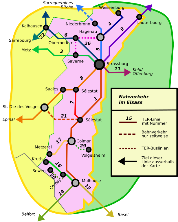
English: Map of Local Railways in Alsace, France Deutsch: Karte der Regionallinien im Elsass, Frankreich |
| Date | (UTC) |
| Source | |
| Author |
|
| Other versions |
Derivative works of this file: |
Licensing[edit]
| This is a retouched picture, which means that it has been digitally altered from its original version. Modifications: Convert to SVG. The original can be viewed here: TER Elsass.png:
|
I, the copyright holder of this work, hereby publish it under the following license:
This file is licensed under the Creative Commons Attribution-Share Alike 3.0 Unported license.
- You are free:
- to share – to copy, distribute and transmit the work
- to remix – to adapt the work
- Under the following conditions:
- attribution – You must give appropriate credit, provide a link to the license, and indicate if changes were made. You may do so in any reasonable manner, but not in any way that suggests the licensor endorses you or your use.
- share alike – If you remix, transform, or build upon the material, you must distribute your contributions under the same or compatible license as the original.
Original upload log[edit]
This image is a derivative work of the following images:
- File:TER_Elsass.png licensed with Cc-by-sa-3.0, Cc-by-sa-3.0/en
- 2008-10-20T20:53:29Z Lantus 314x392 (25129 Bytes) {{Information |Description={{en|1=Map of Local Railways in Alsace, France}} {{de|1=Karte der Regionallinien im Elsass, Frankreich}} |Source=Eigenes Werk (own work) |Author=[[User:Lantus|Lantus]] |Date= |Permission= |other_ver
Uploaded with derivativeFX
File history
Click on a date/time to view the file as it appeared at that time.
| Date/Time | Thumbnail | Dimensions | User | Comment | |
|---|---|---|---|---|---|
| current | 01:47, 25 January 2009 | | 314 × 392 (68 KB) | Grenavitar (talk | contribs) | Fix line breaks |
| 01:26, 25 January 2009 |  | 314 × 392 (60 KB) | Grenavitar (talk | contribs) | Cerney -> Cernay -- even the German article uses this spelling (as do the French and English) | |
| 05:21, 6 January 2009 |  | 314 × 392 (68 KB) | Mfield (talk | contribs) | add accents, correct some spelling | |
| 04:28, 6 January 2009 |  | 314 × 392 (68 KB) | Mfield (talk | contribs) | clean up some lines | |
| 03:38, 6 January 2009 |  | 314 × 392 (68 KB) | Mfield (talk | contribs) | {{Information |Description={{en|1=Map of Local Railways in Alsace, France}} {{de|1=Karte der Regionallinien im Elsass, Frankreich}} |Source=*File:TER_Elsass.png |Date=2009-01-06 03:37 (UTC) |Author=*derivative work: ~~~ *File:TER_Elsass.png: [ |
You cannot overwrite this file.
File usage on Commons
The following 4 pages use this file:
File usage on other wikis
The following other wikis use this file:
- Usage on en.wikipedia.org
- Usage on fr.wikipedia.org