File:Taum Sauk Pumped Storage.jpg

Original file (870 × 591 pixels, file size: 116 KB, MIME type: image/jpeg)
Captions
Captions
Summary[edit]
| Description |
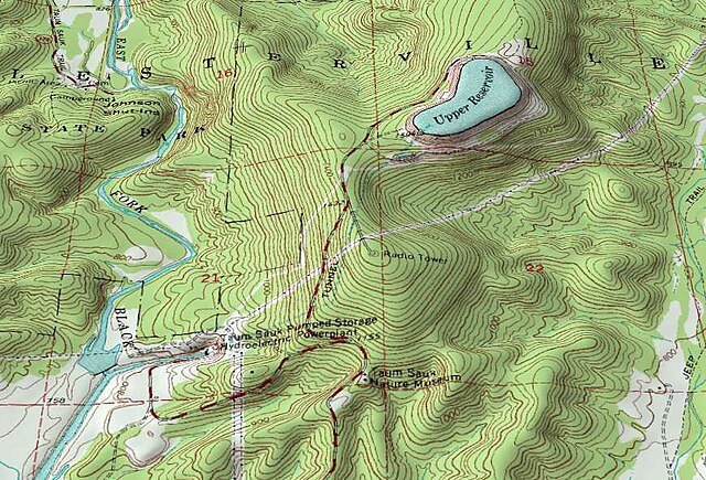
English: An oblique topographic view of the Taum Sauk pumped storage plant. The upper reservoir failed in a catastrophic manner in 2005, destroying part of the neighboring state park. As of 2009 the electrical utility which owns the plant is planning to rebuild the reservoir.
When operational, water from the East Fork Black River is pumped to the reservoir atop of Proffit Mountain at night. During periods of peak daytime demand the hydroelectric plant at the bottom of the mountain can use this to generate over 400MW of power. The water flows through a 7000-foot tunnel connecting the upper reservoir to the power plant. Water for pump-back is stored in a lower reservoir on the river (south of the bounds of this image). Johnson Shut-ins State Park is a short ways upstream from the power plant. For scale, the large numbered red squares (21, 22, etc.) on this topographic map are one square mile (2.6 km²) survey sections. Created by Kbh3rd for Wikipedia with public domain data from the USGS for the 7.5" Johnson Shutins, Missouri, topographic quadrangle (37090E7). This image was created with the 3DEM program. This image was originally uploaded to the English Wikipedia before being uploaded to Wikimedia Commons by the original uploader and copyright holder, Kbh3rd. |
| Date | |
| Source | Own work |
| Author | Kbh3rd |
| Camera location | | View this and other nearby images on: OpenStreetMap |
|---|
Licensing[edit]
- You are free:
- to share – to copy, distribute and transmit the work
- to remix – to adapt the work
- Under the following conditions:
- attribution – You must give appropriate credit, provide a link to the license, and indicate if changes were made. You may do so in any reasonable manner, but not in any way that suggests the licensor endorses you or your use.
- share alike – If you remix, transform, or build upon the material, you must distribute your contributions under the same or compatible license as the original.

|
Permission is granted to copy, distribute and/or modify this document under the terms of the GNU Free Documentation License, Version 1.2 or any later version published by the Free Software Foundation; with no Invariant Sections, no Front-Cover Texts, and no Back-Cover Texts. A copy of the license is included in the section entitled GNU Free Documentation License. |
File history
Click on a date/time to view the file as it appeared at that time.
| Date/Time | Thumbnail | Dimensions | User | Comment | |
|---|---|---|---|---|---|
| current | 05:25, 21 June 2009 | | 870 × 591 (116 KB) | Kbh3rd (talk | contribs) | {{Information |Description={{en|1=An oblique topographic view of the Taum Sauk pumped storage plant. The upper reservoir failed in a catastrophic manner in 2005, destroying part of the neighboring [[:en:Johnson Shut |
You cannot overwrite this file.
File usage on Commons
There are no pages that use this file.
File usage on other wikis
The following other wikis use this file:
- Usage on de.wikipedia.org
- Usage on en.wikipedia.org
- Usage on es.wikipedia.org
- Usage on fa.wikipedia.org
- Usage on fr.wikipedia.org
- Usage on ko.wikipedia.org
- Usage on ms.wikipedia.org
- Usage on no.wikipedia.org
- Usage on sl.wikipedia.org
- Usage on tr.wikipedia.org