File:Tectonic map Mediterranean He.jpg
Jump to navigation
Jump to search

Size of this preview: 800 × 465 pixels. Other resolutions: 320 × 186 pixels | 640 × 372 pixels | 1,024 × 596 pixels | 1,324 × 770 pixels.
Original file (1,324 × 770 pixels, file size: 218 KB, MIME type: image/jpeg)
Captions
Captions
Add a one-line explanation of what this file represents
Summary[edit]
| Description |
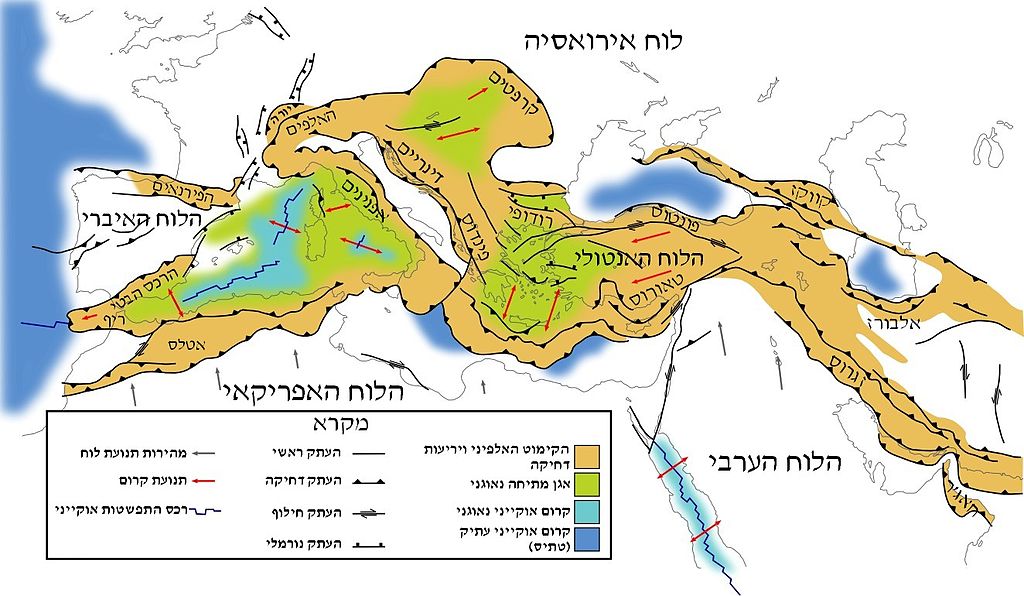
עברית: רכסי מערב החגורה האלפידית במערך הלוחות העכשווי English: Tectonic map of southern Europe and the Middle East, showing tectonic structures of the western Alpide mountain belt. Only Alpine (tertiary) structures are shown. |
| Date | |
| Source | |
| Author | Woudloper, דקי |
| Permission (Reusing this file) |
This file is licensed under the Creative Commons Attribution-Share Alike 3.0 Unported license. Attribution: דקי
|
| Other versions |
[]
|


Licensing[edit]
This file is licensed under the Creative Commons Attribution-Share Alike 1.0 Generic license.
- You are free:
- to share – to copy, distribute and transmit the work
- to remix – to adapt the work
- Under the following conditions:
- attribution – You must give appropriate credit, provide a link to the license, and indicate if changes were made. You may do so in any reasonable manner, but not in any way that suggests the licensor endorses you or your use.
- share alike – If you alter, transform, or build upon this work, you must distribute the resulting work under the same license as the original.
File history
Click on a date/time to view the file as it appeared at that time.
| Date/Time | Thumbnail | Dimensions | User | Comment | |
|---|---|---|---|---|---|
| current | 14:17, 26 April 2014 | | 1,324 × 770 (218 KB) | Tzafrir (talk | contribs) | {{מידע |תיאור=רכסי מערב החגורה האלפידית במערך הלוחות העכשווי |מקור=תרגום לעברית של http://commons.wikimedia.org/wiki/File:Tectonic_map_Mediterranean_EN.svg |תאריך יצירה=31-12-2... |
You cannot overwrite this file.
File usage on Commons
The following 9 pages use this file:
- File:Tectonic map Mediterranean DE.svg
- File:Tectonic map Mediterranean EN.svg
- File:Tectonic map Mediterranean FR.svg
- File:Tectonic map Mediterranean He.jpg
- File:Tectonic map Mediterranean IT.svg
- File:Tectonic map Mediterranean NL.svg
- File:Tectonic map Mediterranean UK.svg
- File:Tectonic map Mediterranean es.svg
- Template:Other versions/Tectonic map Mediterranean
File usage on other wikis
The following other wikis use this file:
- Usage on he.wikipedia.org
- Usage on he.wikivoyage.org
Categories:
- Alpine orogeny
- Atlas Mountains
- Cordilleras Béticas
- Maps of Rhodope
- Maps of Anatolia
- Taurus Mountains
- Maps of the Caucasus
- Armenian Highland
- Maps of the Zagros Mountains
- Maps of the Alborz
- Geological maps of Europe
- Geological maps of Spain
- Geological maps of France
- Geological maps of the Alps
- Geological maps of the Dinaric Alps
- Maps of the Carpathian Mountains
- Maps of the Middle East
- Tectonics maps
- Geological maps of the Mediterranean Sea
- Geology of the Persian Gulf
- Alpide belt