File:Template map of US states and District of Columbia.svg
Jump to navigation
Jump to search

Size of this PNG preview of this SVG file: 512 × 341 pixels. Other resolutions: 320 × 213 pixels | 640 × 426 pixels | 1,024 × 682 pixels | 1,280 × 853 pixels | 2,560 × 1,705 pixels.
Original file (SVG file, nominally 512 × 341 pixels, file size: 52 KB)
Captions
Captions
Template to create choropleth U.S. states and Washington D.C. maps using the SVG-JavaScript generator by cmglee and TilmannR.
Summary[edit]
| Description | |
| Date | - date of first upload to the Commons. See file history for later dates. |
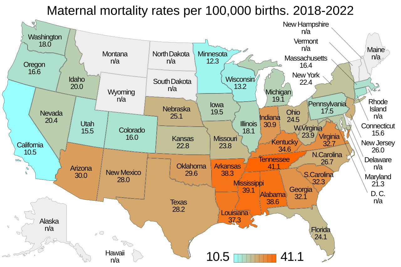
| Source | Data is from Maternal deaths and mortality rates by state, 2018-2021. Listed at Data Files and Resources. National Vital Statistics System (NVSS). National Center for Health Statistics. US Centers for Disease Control and Prevention. |
| Author | User:Cmglee. File:Blank US Map (states only).svg is from en:user:Theshibboleth and others who worked on it. |
.svg)
Licensing[edit]
This file is licensed under the Creative Commons Attribution-Share Alike 4.0 International license.
- You are free:
- to share – to copy, distribute and transmit the work
- to remix – to adapt the work
- Under the following conditions:
- attribution – You must give appropriate credit, provide a link to the license, and indicate if changes were made. You may do so in any reasonable manner, but not in any way that suggests the licensor endorses you or your use.
- share alike – If you remix, transform, or build upon the material, you must distribute your contributions under the same or compatible license as the original.
File history
Click on a date/time to view the file as it appeared at that time.
| Date/Time | Thumbnail | Dimensions | User | Comment | |
|---|---|---|---|---|---|
| current | 08:49, 23 January 2024 | | 512 × 341 (52 KB) | Cmglee (talk | contribs) | Use `...${...}...` notation thanks to Timwi |
| 01:16, 19 January 2024 |  | 512 × 341 (52 KB) | Cmglee (talk | contribs) | Support using USPS 2-letter abbreviations in data table as per http://commons.wikimedia.org/w/index.php?title=File_talk%3ATemplate_map_of_U.S._states_and_District_of_Columbia.svg&diff=843050515&oldid=842743698 | |
| 10:51, 17 January 2024 |  | 512 × 341 (52 KB) | Cmglee (talk | contribs) | Do simple state name matching to let states be omitted or specified in any order, as per https://en.wikipedia.org/w/index.php?title=Wikipedia:Reference_desk/Computing&diff=prev&oldid=1196413257 | |
| 15:35, 16 January 2024 |  | 512 × 341 (49 KB) | Cmglee (talk | contribs) | Update JavaScript as per https://commons.wikimedia.org/w/index.php?title=User_talk%3ATilmannR&diff=841775008&oldid=841685534 | |
| 04:47, 15 January 2024 |  | 512 × 341 (49 KB) | Cmglee (talk | contribs) | Update JavaScript and move Georgia labels | |
| 18:29, 14 January 2024 |  | 512 × 341 (49 KB) | Cmglee (talk | contribs) | Uploaded a work by Timeshifter from template: File:Template map of U.S. states and District of Columbia.svg and instructions: File talk:Template map of U.S. states and District of Columbia.svg/Instructions. See more info: en:User:Timeshifter/Sandbox202 and en:User:Timeshifter/Sandbox207. from {{own}} from [https://www.cdc.gov/nchs/maternal-mortality/mmr-2018-2021-state-data.pdf Maternal deaths and mortality rates by state, 2018-2021]. Listed at [https:/... |
You cannot overwrite this file.
File usage on Commons
The following 5 pages use this file:
- User:Magog the Ogre/Multilingual legend/2024 January 13-16
- User:Magog the Ogre/Multilingual legend/2024 January 17-21
- User:Magog the Ogre/Multilingual legend/2024 January 22-26
- File talk:Template map of US states and District of Columbia.svg
- File talk:Template map of US states and District of Columbia.svg/Instructions
File usage on other wikis
The following other wikis use this file:
- Usage on en.wikipedia.org