File:The Millennium Cross on Dirrington Little Law - geograph.org.uk - 1414821.jpg
Jump to navigation
Jump to search

Size of this preview: 400 × 600 pixels. Other resolutions: 160 × 240 pixels | 427 × 640 pixels.
Original file (427 × 640 pixels, file size: 180 KB, MIME type: image/jpeg)
Captions
Captions
Add a one-line explanation of what this file represents
Summary
[edit]| Description |
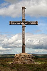
English: The Millennium Cross on Dirrington Little Law This Millennium Cross is perched on a prominent position on Dirrington Little Law (363m) 6 miles west of Duns on the southern edge of the Lammermuir Hills. Organised by local churches and constructed by local craftsmen, the 5m high cross was airlifted into position by an army helicopter. 250 people, including a brass ensemble, gathered at the summit on a cold damp afternoon on Sunday 11th June 2000 for the official ecumenical dedication service, with representatives of 9 different churches taking part. On a previous visit to the hill, there was a visitors book within a small metal box, but there is no trace of this now. A small metal plaque near the base of the cross reads:-
The Millennium Cross Built by a group of Berwickshire Churches and Dedicated to God 11 June 2000 (Source of some information: Berwickshire News) |
| Date | |
| Source | From geograph.org.uk |
| Author | Walter Baxter |
| Attribution (required by the license) | Walter Baxter / The Millennium Cross on Dirrington Little Law / |
| Camera location | | View this and other nearby images on: OpenStreetMap |
|---|
| Object location | | View this and other nearby images on: OpenStreetMap |
|---|
Licensing
[edit]
|
This image was taken from the Geograph project collection. See this photograph's page on the Geograph website for the photographer's contact details. The copyright on this image is owned by Walter Baxter and is licensed for reuse under the Creative Commons Attribution-ShareAlike 2.0 license.
|
This file is licensed under the Creative Commons Attribution-Share Alike 2.0 Generic license.
Attribution: Walter Baxter
- You are free:
- to share – to copy, distribute and transmit the work
- to remix – to adapt the work
- Under the following conditions:
- attribution – You must give appropriate credit, provide a link to the license, and indicate if changes were made. You may do so in any reasonable manner, but not in any way that suggests the licensor endorses you or your use.
- share alike – If you remix, transform, or build upon the material, you must distribute your contributions under the same or compatible license as the original.

_heading:315.00&language=en)
_heading:315.00&language=en)
File history
Click on a date/time to view the file as it appeared at that time.
| Date/Time | Thumbnail | Dimensions | User | Comment | |
|---|---|---|---|---|---|
| current | 17:15, 1 March 2011 | | 427 × 640 (180 KB) | GeographBot (talk | contribs) | == {{int:filedesc}} == {{Information |description={{en|1=The Millennium Cross on Dirrington Little Law This Millennium Cross is perched on a prominent position on Dirrington Little Law (363m) 6 miles west of Duns on the southern edge of the Lammermuir Hil |
You cannot overwrite this file.
File usage on Commons
There are no pages that use this file.