File:The Rufus Stone - geograph.org.uk - 1432228.jpg
Jump to navigation
Jump to search
No higher resolution available.
The_Rufus_Stone_-_geograph.org.uk_-_1432228.jpg (640 × 480 pixels, file size: 156 KB, MIME type: image/jpeg)
Captions
Captions
Add a one-line explanation of what this file represents
Summary[edit]
| Description |
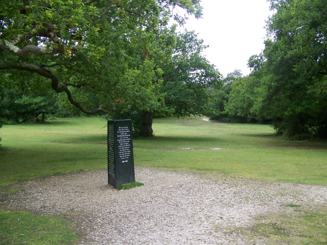
English: The Rufus Stone The Rufus Stone was erected by Earl De La Warr in 1745 and marks the presumed spot where William II was killed by an arrow fired by Walter Tyrrell, while hunting on 2nd August 1100. The killing was said to be accidental. The King's youngest brother, Henry, hearing of his brother's death, rode to Winchester, seized the treasury and had himself proclaimed king by the barons, forestalling the claims of his eldest brother, Robert of Normandy. |
| Date | |
| Source | From geograph.org.uk |
| Author | Trish Steel |
| Camera location | | View this and other nearby images on: OpenStreetMap |
|---|
_heading:90.00&language=en)
| Object location | | View this and other nearby images on: OpenStreetMap |
|---|
_heading:90.00&language=en)
Licensing[edit]

|
This image was taken from the Geograph project collection. See this photograph's page on the Geograph website for the photographer's contact details. The copyright on this image is owned by Trish Steel and is licensed for reuse under the Creative Commons Attribution-ShareAlike 2.0 license.
|
This file is licensed under the Creative Commons Attribution-Share Alike 2.0 Generic license.
Attribution: Trish Steel
- You are free:
- to share – to copy, distribute and transmit the work
- to remix – to adapt the work
- Under the following conditions:
- attribution – You must give appropriate credit, provide a link to the license, and indicate if changes were made. You may do so in any reasonable manner, but not in any way that suggests the licensor endorses you or your use.
- share alike – If you remix, transform, or build upon the material, you must distribute your contributions under the same or compatible license as the original.
File history
Click on a date/time to view the file as it appeared at that time.
| Date/Time | Thumbnail | Dimensions | User | Comment | |
|---|---|---|---|---|---|
| current | 00:05, 2 March 2011 | | 640 × 480 (156 KB) | GeographBot (talk | contribs) | == {{int:filedesc}} == {{Information |description={{en|1=The Rufus Stone The Rufus Stone was erected by Earl De La Warr in 1745 and marks the presumed spot where William II was killed by an arrow fired by Walter Tyrrell, while hunting on 2nd August 1100. |
You cannot overwrite this file.
File usage on Commons
There are no pages that use this file.