File:TochigikenDo263Go2005-6.jpg
Jump to navigation
Jump to search

Size of this preview: 800 × 600 pixels. Other resolutions: 320 × 240 pixels | 640 × 480 pixels | 1,024 × 768 pixels | 1,280 × 960 pixels.
Original file (1,280 × 960 pixels, file size: 563 KB, MIME type: image/jpeg)
Captions
Captions
Add a one-line explanation of what this file represents
Summary[edit]
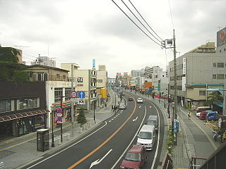
| Description | Tochigi Prefectural Road 263 Oyamateishajo Line. Oyama, Tochigi prefecture, Japan. |
| Date | 3 June 2005 (according to Exif data) |
| Source | No machine-readable source provided. Own work assumed (based on copyright claims). |
| Author | No machine-readable author provided. Kinori assumed (based on copyright claims). |
Licensing[edit]
Kinori, the copyright holder of this work, hereby publishes it under the following license:
| I, the copyright holder of this work, release this work into the public domain. This applies worldwide. In some countries this may not be legally possible; if so: I grant anyone the right to use this work for any purpose, without any conditions, unless such conditions are required by law. |
ja: 栃木県道263号小山停車場線[edit]
en: Tochigi Prefectural Road 263 Oyamateishajō Line[edit]
- Place - Shiroyamachō 2 chōme, Oyama, Tochigi Prefecture, Japan. From Shiroyamachō Footbridge toward east.
- Date - June 3, 2005.
- Photographer - Kinori.
- The west street of the Oyama Station. We can see the station building at the end of the road.
es: la Carretera prefectural de Tochigi 263 Línea Oyamateichajó[edit]
- Lugar - Shiroyamachō 2 chōme, Oyama, prefectura de Tochigi, Japón. Desde el Puente Shiroyamachō hacia este.
- Fecha - Junio 3, 2005.
- Fotógrafo - Kinori.
- El carretera oeste de la Estación Oyama. Podemos ver el edificio de la estación en el fin de la vía.
Link to[edit]
- ja:小山市
- image:Kokudo4Go2005-6Oyama.jpg (Northward from the same place)
File history
Click on a date/time to view the file as it appeared at that time.
| Date/Time | Thumbnail | Dimensions | User | Comment | |
|---|---|---|---|---|---|
| current | 10:43, 15 June 2005 | | 1,280 × 960 (563 KB) | Kinori (talk | contribs) | Tochigi Prefectural Road 263 Oyamateishajo Line. Oyama, Tochigi prefecture, Japan. {{PD-user|Kinori}} |
You cannot overwrite this file.
File usage on Commons
There are no pages that use this file.
File usage on other wikis
The following other wikis use this file:
- Usage on de.wikipedia.org
- Usage on es.wikipedia.org