File:Topographic map of Saint Helena-fr.svg
Jump to navigation
Jump to search

Size of this PNG preview of this SVG file: 740 × 600 pixels. Other resolutions: 296 × 240 pixels | 592 × 480 pixels | 948 × 768 pixels | 1,264 × 1,024 pixels | 2,527 × 2,048 pixels | 802 × 650 pixels.
Original file (SVG file, nominally 802 × 650 pixels, file size: 595 KB)
Captions
Captions
Add a one-line explanation of what this file represents
| Description |
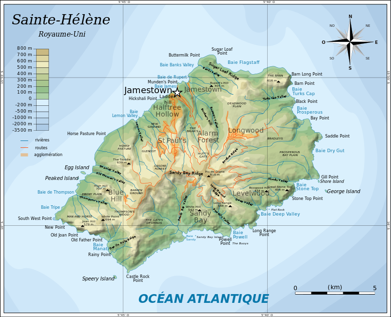
English: Topographic map of the British island of Saint Helena.
Français : Carte topographique de l'île britannique de Sainte-Hélène. |
| Date | (UTC) |
| Source | |
| Author |
|
| This is a retouched picture, which means that it has been digitally altered from its original version. Modifications: traduction. The original can be viewed here: Topographic map of Saint Helena-en.svg:
|
I, the copyright holder of this work, hereby publish it under the following licenses:
This file is licensed under the Creative Commons Attribution-Share Alike 3.0 Unported license.
- You are free:
- to share – to copy, distribute and transmit the work
- to remix – to adapt the work
- Under the following conditions:
- attribution – You must give appropriate credit, provide a link to the license, and indicate if changes were made. You may do so in any reasonable manner, but not in any way that suggests the licensor endorses you or your use.
- share alike – If you remix, transform, or build upon the material, you must distribute your contributions under the same or compatible license as the original.

|
Permission is granted to copy, distribute and/or modify this document under the terms of the GNU Free Documentation License, Version 1.2 or any later version published by the Free Software Foundation; with no Invariant Sections, no Front-Cover Texts, and no Back-Cover Texts. A copy of the license is included in the section entitled GNU Free Documentation License. |
You may select the license of your choice.
Original upload log
[edit]
This image is a derivative work of the following images:
- File:Topographic_map_of_Saint_Helena-en.svg licensed with Cc-by-sa-3.0, GFDL
- 2010-08-10T05:54:46Z Mysid 802x650 (596823 Bytes) legend for roads, rivers, agglomeration
- 2010-08-09T21:42:54Z Mysid 802x650 (594310 Bytes) bugfix #2
- 2010-08-09T21:40:19Z Mysid 802x650 (266379 Bytes) bugfix
- 2010-08-09T21:27:26Z Mysid 647x594 (592648 Bytes) {{Information |Description={{en|1=Topographic map of the British island of [[w:Saint Helena|]].}} |Source=Self-made in Inkscape. Based on several sources. |Author=[[w:User:Mysid|Mysid]] |Date=2010-08-10 |Permission= |other_ve
Uploaded with derivativeFX
File history
Click on a date/time to view the file as it appeared at that time.
| Date/Time | Thumbnail | Dimensions | User | Comment | |
|---|---|---|---|---|---|
| current | 14:22, 17 October 2010 | | 802 × 650 (595 KB) | Treehill (talk | contribs) | correction noms |
| 19:43, 15 October 2010 |  | 802 × 650 (592 KB) | Treehill (talk | contribs) | traduction de Diane's Peak en Pic de Diane ([http://www.lautresaintehelene.com/autre-sainte-helene-lieux-ile.html rencontré ici]). | |
| 19:31, 15 October 2010 |  | 802 × 650 (591 KB) | Treehill (talk | contribs) | {{Information |Description={{en|1=Topographic map of the British island of Saint Helena.}} {{fr|1=Carte topographique de l'île britannique de Sainte-Hélène.}} |Source=*[[:File:Topographic_map_of_Saint_Helena-en |
You cannot overwrite this file.
File usage on Commons
The following 5 pages use this file:
File usage on other wikis
The following other wikis use this file:
- Usage on ca.wikipedia.org
- Usage on fr.wikipedia.org
- Usage on fr.wikivoyage.org
- Usage on ga.wikipedia.org
- Usage on gl.wikipedia.org
- Usage on lb.wikipedia.org
- Usage on www.wikidata.org