File:Tree Map of Industries by Share in New York (2014).png
Jump to navigation
Jump to search
Size of this preview: 800 × 228 pixels. Other resolutions: 320 × 91 pixels | 640 × 183 pixels | 1,024 × 292 pixels | 1,280 × 365 pixels | 4,776 × 1,362 pixels.
Original file (4,776 × 1,362 pixels, file size: 1.41 MB, MIME type: image/png)
Captions
Captions
Add a one-line explanation of what this file represents
Summary[edit]
.png&action=edit§ion=1)
| Description |
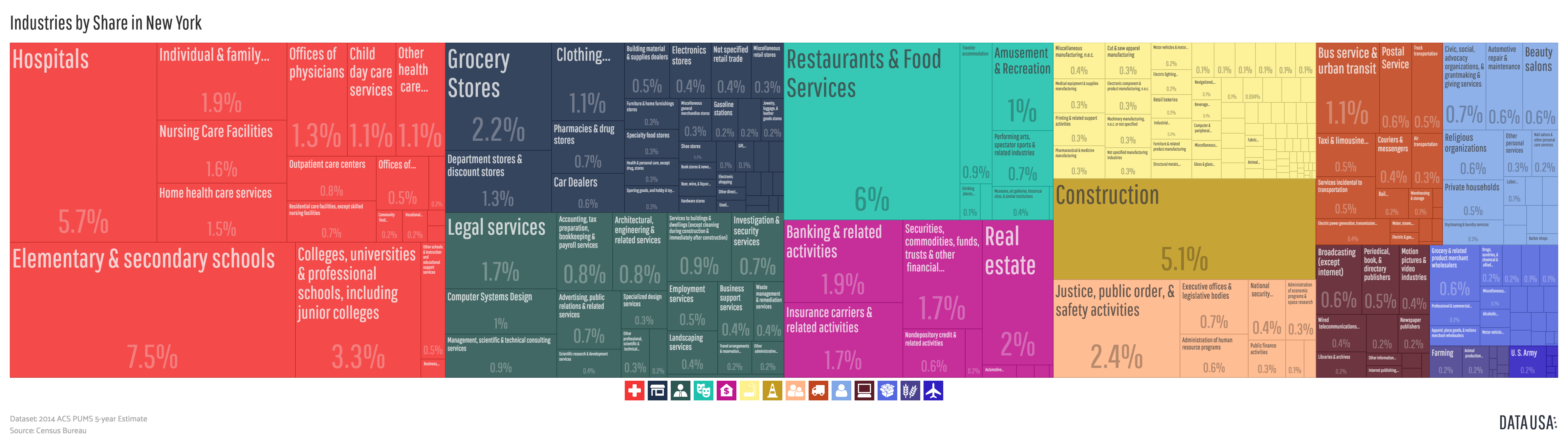
English: A tree map showing New York State's economy by industry according to ACS PUMS 5-year estimates (2014). Percentages represent size of industry by employed population. |
| Date | |
| Source | http://datausa.io/profile/geo/new-york/#tmap_ind_num_emp |
| Author | Datawheel, LLC |
Licensing[edit]
.png&action=edit§ion=2)

|
This work is free software; you can redistribute it and/or modify it under the terms of the GNU Affero General Public License as published by the Free Software Foundation; either version 3 of the License, or any later version. This work is distributed in the hope that it will be useful, but without any warranty; without even the implied warranty of merchantability or fitness for a particular purpose. See version 3 of the GNU Affero General Public License for more details.
|
File history
Click on a date/time to view the file as it appeared at that time.
| Date/Time | Thumbnail | Dimensions | User | Comment | |
|---|---|---|---|---|---|
| current | 15:49, 8 June 2016 | 4,776 × 1,362 (1.41 MB) | Mattrdini (talk | contribs) | User created page with UploadWizard |
You cannot overwrite this file.
File usage on Commons
There are no pages that use this file.
.png&oldid=459461003)